Manuscripts
Ranchos Providencia and Cahuenga: Survey No. 45, showing structures, parcel owners, and surface detail, sec. 28-30, T.1N. R.14W. S.B.M

You might also be interested in
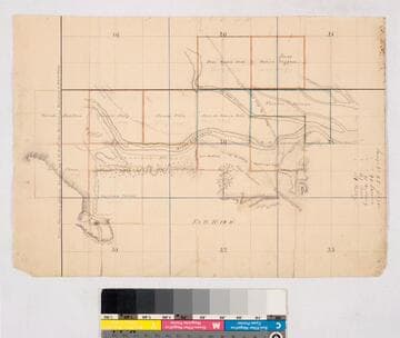
Ranchos Providencia and Cahuenga: parcels along Los Angeles River, showing structures, parcel owners, and surface detail, sec. 20, 21, 28-31, T.1N. R.14W. S.B.M., combining surveys 45, 90, 91, 107, 114
Manuscripts
Mission San Fernando. Color highlights, key to surveys; fine hachures, landowners including Bodillero, Feliz, Moreno, Lacarra, Martinez, Valdez; roads to Los Angeles, to Encino, to San Fernando; Los Angeles River. Title supplied by cataloger.
mssSolano SR_Map_0111

Rancho La Brea and adjacent public lands, showing owners of parcels in sec.s 10, 11, 13-15, 23-24, T.1S. R. 14W. S.B.M
Manuscripts
Hachures; waterways, dry wash from Cahuenga indicated. Parcel owners: Chapman, Glassell, Reese, Pickens, Offutt, McPherson, Van de Graaff, Travis. T 1 S.R. 14 W. Title supplied by cataloger.
mssSolano SR_Map_0029
Image not available
[Public lands: T.7N. R.14W. S.B.M., showing structures, some surface detail, and names of parcel owners]
Manuscripts
The collection consists of maps, field books, legal documents, business papers, and diaries related to the work of surveyors George Hansen, Alfred Solano, Sidney B. Reeve, and others. The maps and surveys in the collection are of the city of Los Angeles, Southern California ranchos, and subdivisions of the city of Los Angeles and neighboring towns. The collection contains over maps and sketch maps. Other subjects represented in the collection include: civil engineering, land subdivision, mines and mineral resources, and daily life in Los Angeles and Los Angeles County.
mssSolano

Rancho La Ciénega showing parcels, surface features, & owners in portions of T.1S. R.14-15W., and T.2S. R.14W. S.B.M
Manuscripts
Rancho Ygnacio Machado - Aguaje de Centinela and Rancho Ballona indicated on map. Hachures, color highlights. Title supplied by cataloger.
mssSolano SR_Map_0043
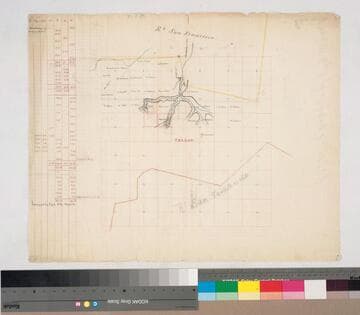
Rancho San Francisco: parcels beyond southern boundary in sec. 4-11, 14-17, T.3N. R.16W. S.B.M
Manuscripts
Rancho San Fernando to the south Indicates names of owners, surface detail in hachures; waterways; color highlights On printed township grid; table with courses & boundary data. Title supplied by cataloger.
mssSolano SR_Map_0145

Land exchange parcels and topographic detail in sec. 34-36, T.3S. R.8W. and sec. 1-3, 10-12, T.4S. R.8W. S.B.M
Manuscripts
RANCHO LOMAS dE SANTIAGO. Very dense hachures. Title supplied by cataloger.
mssSolano SR_Map_0085