Manuscripts
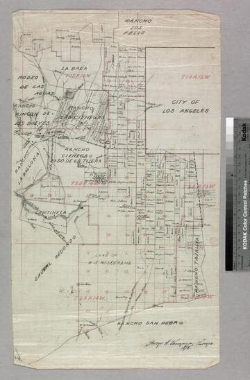
Rancho La Ciénega showing parcels, surface features, & owners in portions of T.1S. R.14-15W., and T.2S. R.14W. S.B.M

You might also be interested in

Los Angeles County public lands in sec. 19, T.2S. R. 14W. S.B.M
Manuscripts
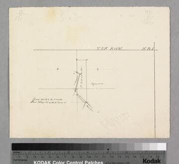
Bordered by Ranchos Aguaje de la Centinela, Ballona. Sketch map on lined paper with acreage and other figures; notations on verso. Title supplied by cataloger.
mssSolano SR_Map_0767.02
Los Angeles County public lands : T. 1S. R. 13-14W., T.2S. R. 13-14W., and T.3S. R. 13-14W. S.B.M
Manuscripts
Shows Ranchos Aguaje de Centinela, Rodeo de las Aguas, La Brea, Los Felis, Las Cienegas, Rincon de Los Bueyes, La Ballona, Cienega Paso de la Tijera, Sausal Redondo, San Pedro, Tajauta; City of Los Angeles, Land of W.S. Rosecrans. Showing structures, townships, section numbers, surface detail, parcel owners; color highlighting. Title supplied by cataloger.
mssSolano SR_Map_0769

Los Angeles County public lands SW of Los Angeles : Sec. 17-22, T.2S. R. 14W. S.B.M
Manuscripts
Boundaries with Ranchos Aguaje de la Centinela, Sausal Redondo, la Ballona, and Ciénega ó Paso de la Tijera*. On printed Township Map grid with Meanders and survey data tables; notation re: railroad add sections; shows parcel owners; color highlighting. Title supplied by cataloger.
mssSolano SR_Map_0767.01

Los Angeles County public lands sec. 21-22, T.2S. R. 14W. S.B.M
Manuscripts
Bordered by Ranchos Aguaje de la Centinela, Sausal Redondo. Sketch map on lined paper with acreage and other figures; notations on verso in ink. Title supplied by cataloger.
mssSolano SR_Map_0767.03
Image not available
Rancho La[s] Ciénega[s, showing parcels, surface features, & owners in portions of T.1S. R.14-15W., and T.2S. R.14W. S.B.M.]
Manuscripts
The collection consists of maps, field books, legal documents, business papers, and diaries related to the work of surveyors George Hansen, Alfred Solano, Sidney B. Reeve, and others. The maps and surveys in the collection are of the city of Los Angeles, Southern California ranchos, and subdivisions of the city of Los Angeles and neighboring towns. The collection contains over maps and sketch maps. Other subjects represented in the collection include: civil engineering, land subdivision, mines and mineral resources, and daily life in Los Angeles and Los Angeles County.
mssSolano
Los Angeles County public lands : Larcade parcel, Sec. 2-3, T.2 S. R. 14 W. S.B.M
Manuscripts
Bordered by Ranchos Aguaje de la Centinela . Surveyed May 25-26, June 5 (no year indicated); pencil calculations. Title supplied by cataloger.
mssSolano SR_Map_0767.04