Visual Materials
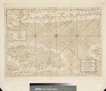
New Map of the Island of Jamaica Divided into its Parishes Including the South End of Cuba and the West End of Hispaniola with the Trade Winds &c. Drawn from the best Surveys by Thos. Kitchin Geogr

You might also be interested in
A new map of the island of Jamaica : divided into its parishes including the south end of Cuba and the west end of Hispaniola with the trade winds &c / drawn from the best surveys by Thos. Kitchin Geogr
Visual Materials
Two submaps. Kashnor dates as ca. 1780. Jolly notes London Magazine publication date as July 1763. Duplicate of 105:461. Submaps: Chart of the Windward Passage; Plan of Port Royal Harbour. MS note: 461 (on backing). Prime meridian: London. Relief: pictorial. Graphic Scale: Miles. Projection: Cylindrical. Printing Process: Copper engraving. Other Features: Sub-maps. References: Jolly Brit. Period. LOND-228.
105:460 M

A new chart of the seas surrounding the island of Cuba : with the soundings, currents, ships courses &c and a map of the island itself lately made by an officer in the Navy
Visual Materials
Jolly attributes the engraving to Kitchin. Sub-map: Plan of the Harbour and Town of Havana. MS note: 384 (on backing). Prime meridian: London. Relief: pictorial. Graphic Scale: Miles. Projection: Cylindrical. Watermark: Seal. Printing Process: Copper engraving. References: Jolly British Periodicals LOND-217.
105:384 S

New & Accurate Map of the Island of Jamaica Divided into its Parishes, Containing theTowns, Plantations, Forts, Capes, Bays, &c. from all the Surveys made there of the Year 1755
Visual Materials
Two submaps. Submap: The Harbour of Port-Royal; Particular Plan of Port Royal before the Earthquake in 1692 and after the present year of 1755. . Prime meridian: London. Relief: pictorial. Graphic Scale: Miles. Projection: Cylindrical. Printing Process: Copper engraving. Other Features: Sub-maps.
093:800 M