Visual Materials
A new map of the island of Jamaica : divided into its parishes including the south end of Cuba and the west end of Hispaniola with the trade winds &c / drawn from the best surveys by Thos. Kitchin Geogr

You might also be interested in
New Map of the Island of Jamaica Divided into its Parishes Including the South End of Cuba and the West End of Hispaniola with the Trade Winds &c. Drawn from the best Surveys by Thos. Kitchin Geogr
Visual Materials
Two submaps. Kashnor dates as ca. 1780. Jolly notes London Magazine publication date as July 1763. Duplicate of 105:460. Submaps: Chart of the Windward Passage; Plan of Port Royal Harbour. MS note: 460 (on backing). Prime meridian: London. Relief: pictorial. Graphic Scale: Miles. Projection: Cylindrical. Printing Process: Copper engraving. Other Features: Sub-maps. References: Jolly Brit. Period. LOND-228.
105:461 M

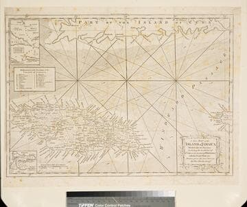
A new chart of the seas surrounding the island of Cuba : with the soundings, currents, ships courses &c and a map of the island itself lately made by an officer in the Navy
Visual Materials
Jolly attributes the engraving to Kitchin. Sub-map: Plan of the Harbour and Town of Havana. MS note: 384 (on backing). Prime meridian: London. Relief: pictorial. Graphic Scale: Miles. Projection: Cylindrical. Watermark: Seal. Printing Process: Copper engraving. References: Jolly British Periodicals LOND-217.
105:384 S

New & Accurate Map of the Island of Jamaica Divided into its Parishes, Containing theTowns, Plantations, Forts, Capes, Bays, &c. from all the Surveys made there of the Year 1755
Visual Materials
Two submaps. Submap: The Harbour of Port-Royal; Particular Plan of Port Royal before the Earthquake in 1692 and after the present year of 1755. . Prime meridian: London. Relief: pictorial. Graphic Scale: Miles. Projection: Cylindrical. Printing Process: Copper engraving. Other Features: Sub-maps.
093:800 M