Visual Materials
Birdseye View. Big Creek-San Joaquin River. Water Power Development of the Southern California Edison Co

You might also be interested in
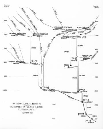
This 1922 map shows the proposed ultimate development of the Big Creek Project to a size even larger than that first envisioned by John Eastwood
Visual Materials
This 1922 map shows the proposed ultimate development of the Big Creek Project to a size even larger than that first envisioned by John Eastwood. Still later plans added more powerhouses on the South Fork of the San Joaquin, but none were built before the depression ended work. Today, the Balsam Meadows Plant is near the site of old Powerhouse #5. Pg. 103.
photCL SCE 11 - 00208

View of Big Creek Powerhouses #2 and 2A from across the forebay at waters edge
Visual Materials
View of Big Creek Powerhouses #2 and 2A from across the forebay at waters edge.
photCL SCE 05 - 54819
Big Creek Powerhouse #8. located at the junction of Big Creek (at left) and the San Joaquin River
Visual Materials
Big Creek Powerhouse #8, located at the junction of Big Creek (at left) and the San Joaquin River, viewed from upstream.
photCL SCE 12 - 00227

Map of Big Creek No. 8 Development for Val. Dept
Visual Materials
Map of Big Creek No. 8 Development for Val. Dept. - includes location of Powerhouses 8, 2, & 2a, Dams 5 & 6, Tunnel 8, Camps 7, 31, 32, 33, & 42, penstock, transmission lines, roads and railroads.
photCL SCE 02 - 16223

Junction Big Creek & San Joaquin River
Visual Materials
Junction Big Creek & San Joaquin River, looking up San Joaquin River.
photCL SCE 02 - 05734
Image not available
This map shows the powerhouses and main reservoirs on the Big Creek Project
Visual Materials
This map shows the powerhouses and main reservoirs on the Big Creek Project, as of 1986. Not shown are the tunnels and conduits that transfer water between reservoirs.
photCL SCE 12 - 00220