Visual Materials
At the mouth of Kern River Canyon: the spillway of San Joaquin Light & Power Company's Kern Plant

You might also be interested in

Natural spillway for Power Development Company's hydro plant at the mouth of Kern Canyon
Visual Materials
Natural spillway for Power Development Company's hydro plant at the mouth of Kern Canyon.
photCL SCE 01 - 00723

The Power Development Company's hydro plant at the mouth of the Kern Canyon
Visual Materials
The Power Development Company's hydro plant at the mouth of the Kern Canyon.
photCL SCE 01 - 00724
Image not available
Photographs of the site of Pacific Light and Power Company's San Joaquin River power plant
Visual Materials
An album with 79 amateur and commercial photographs of landscape views of the San Joaquin River area in Fresno County, California, showing sites related to development and early construction of the Pacific Light and Power Company's power plant. The photographs appear to document the promotion of the Mammoth Power Company and the Pacific Light & Power Company's Big Creek projects, along with views of engineers or survey parties in the field and scenic panoramas. The accompanying photograph legend identifies some of these as dam sites and reservoir sites. Local landmarks shown include San Joaquin Canyon, Kerckhoff Dome, several waterfalls along the river, Ray City camp, and Jackson's Bridge on Big Creek. Some of the photographs show landscapes covered with snow. There is one photograph of a Native American woman with a child.
photCL 139

The mouth of Kern River Canyon looking West (downstream)
Visual Materials
The mouth of Kern River Canyon looking West (downstream), showing the Kern River.
photCL SCE 01 - 00616
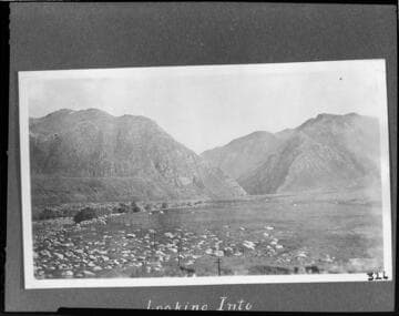
Looking into the mouth of Kern River Canyon (East
Visual Materials
Looking into the mouth of Kern River Canyon (East, upstream).
photCL SCE 01 - 00615

Mouth of the tunnel for the flowline at Kern River #1 Hydro Plant
Visual Materials
Mouth of the tunnel for the flowline at Kern River #1 Hydro Plant.
photCL SCE 01 - 00590