Visual Materials
MS map - Nova Hispania Nova Galicia Guatimala
You might also be interested in
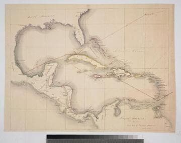
MS map of Central America
Visual Materials
Kashnor notes, "Drawn by James Saurce, of Belize, British Honduras, evidently in connection with some scheme at Vera Paz. [central Guatemala, see 093:670m] It shows the sailing routes to Vera Cruz, Havanna, Jamaica and Grenada." Kashnor dates as ca. 1840. MS note: MS map of Central America circa 1840 (in pencil). Relief: no. Projection: Cylindrical. Verso Text: MS note: 668.
093:668 M
Image not available
Nova Hispania, et Nova Galicia
Visual Materials
See also 105:521M and RB 150259. Kashnor notes, "an early impression." This version lacks the two boxes in lower right cartouche with the scale and "Guiljelmus Blaeuw excudit." With the blank verso it is a variant of Van der Krogt 9510:2. Possibly exchanged between folders. Prime meridian: Ferro. Relief: pictorial. Projection: Cylindrical. Printing Process: Copper engraving. Verso Text: MS note: 521 cat 105.
093:678 M
Image not available
Pascaerte Van Nova Hispania Chili, Preu, en Guatimala
Visual Materials
Kashnor notes, "Shows a good outline of Yucatan, Honduras and the Isthmus of Panama." Cartouche: Natice children.. Relief: no. Graphic Scale: Leagues. Projection: Cylindrical. Printing Process: Copper engraving. Other Features: Cartouche. Verso Text: MS note: 695.
093:695 M
Image not available
Nova Hispania et Nova Galicia
Rare Books
Appeared in and publisher info from Van der Krogt (map 9510:2). See also: 105:521, 093:678 in Museum Bookstore Collection. Previous mat dated as 1630, probably too early, Kashnor dated his copies as 1650. Elaborate cartouche with Spanish coat of arms. Armadillos below. Prime meridian: Ferro. Relief: pictorial. Graphic Scale: Miles. Projection: Cylindrical. Printing Process: Copper engraving. Verso Text: Nova Hispania [text in Latin]; K; 11. MS notes: 345- Dodd - II - 1919 MS/LVN.
150259
Image not available
Nova Hispania et Nova Galacia
Visual Materials
Kashnor dates as ca. 1650. This map may have been exchanged with 093:678 at some time. Colored version of map can be seen in Blaeu's 1663 French edition of Le Grande Atlas (RB 74701 v. 12 p. 29). With the blank verso it is a variant of Van der Krogt 9510:2. Elaborate cartouche with Spanish coat of arms. Armadillos below. See also RB 150259. Prime meridian: Ferro. Relief: pictorial. Graphic Scale: Miles. Projection: Cylindrical. Printing Process: Copper engraving. Verso Text: MS notes: 678/ 93.
105:521 M
Image not available
New Map of the Terraqueous Globe according to the Ancient Discoveries and most general Divisions of it into Continents and Oceans
Visual Materials
Kashnor notes," On the North-West Coast the line only reaches to Northern California, which is represented as an island. Part of New Zealand and New Holland is also shown." Kashnor dates as [1698], Shirley dates 1700-01. This is the second world map in Wells' atlas, 093:047M is the first similar map from the same atlas, per Shirley. Cartouche of figures representing continents and views of Oxford.. Prime meridian: London. Relief: no. Graphic Scale: No. Projection: Dual Hemisphere. Printing Process: Copper engraving. Other Features: CartoucheVignettes. References: Shirley 609.. Verso Text: MS. note: 198.
093:198 M