Visual Materials
1953 Boy Scout Jamboree
You might also be interested in
Image not available
Map of the Town of Earlham
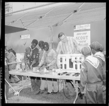
Visual Materials
Old shelf number: eph J4-10(6). In today's eastern part of the City of Orange. Chatman Street is today's Chapman Avenue. Alameda St. became Hewes St. Hotel Blount shown but not located. Vignette: Hotel Blount. Prime meridian: GM. Relief: no. Graphic Scale: Feet. Projection: Plane. Printing Process: Letterpress. Verso Text: MS note: Eph J4-10(6).
ephMPCALIFT0069

Boy Scouting Jamboree with booths focused on usage of electricity
Visual Materials
Boy Scouting Jamboree with booths focused on usage of electricity. [with 10 variants]
photCL SCE 06 - 70976
Boy Scout Jamboree (Centinela Valley District BSA) in a large sports arena
Visual Materials
[Boy Scout Jamboree (Centinela Valley District BSA) in a large sports arena, with exhibits on Thomas Edison.] [with 10 variants]
photCL SCE 06 - 72718
Image not available
Map of the Riverside Orange Belt, San Bernardino Co. California. Compiled by Ad. S. Alkire
Visual Materials
Old shelf number: eph J4-11a (4). From Riverside to Corona, here known as South Riverside. Note the "Famous Tin Mines." Tin Mine Rd. still exists near Lake Mathews. While this map is larger than ephMPCALIF0023&24, the scale is the same and derived from the same original map. Quote," There is no other such all-the-year-round climate known to man." (written before smog.) Prime meridian: GM. Relief: hachures. Graphic Scale: Miles. Projection: Cylindrical. Printing Process: Lithography. Verso Text: MS notes: Eph j4-11a(4). 34j R1/8 stickers: No. 81 84 (both crossed out).
ephMPCALIF0025
Image not available
[Buena Park, portion.]
Visual Materials
Old shelf number: eph J4-10(5). A portion of a larger map. Grand Avenue became Beach Blvd., 6th Street became Commonwealth Avenue. An MS note states "Santa Fe Railroad was moved 2000 ft north." Today's Santa Ana Freeway parallels the Southern Pacific R.R. tracks shown here. Prime meridian: GM. Relief: no. Graphic Scale: Feet. Projection: Plane. Printing Process: Lithography. Verso Text: MS notes: Buena Park Los Angeles Co. L/3/11.
ephMPCALIF0013
Image not available
Map of the proposed line of Montgomery Avenue from the corner of Washington and Montgomery Street to the corner of Union and Stockton Street
Visual Materials
Old shelf number: eph J4-2 (8). This proposed Montgomery Avenue became today's Columbus Avenue]Street to the corner of Union and Stockton Street. Columbus Avenue was apparently completed after a number of buildings were in place, including a church and the county jail. Comparison with maps of San Francisco from contemporary directories shows that Montgomery Avenue was in place by 1873, but not in 1869. Prime meridian: GM. Relief: no. Graphic Scale: Feet. Projection: Plane. Printing Process: Lithography. Verso Text: MS note: Montgomery Avenue but not the line adopted.
ephMPCALIF0004