Rare Books
Map of the northern part of the State of Maine and of the adjacent British provinces : shewing the portion of that state to which Great Britain lays claim reduced from the official map A with corrections from the latest surveys / by S.L. Dashiell
You might also be interested in
Image not available
Map of the northern part of the State of Maine and of the adjacent British provinces : shewing the portion of that state to which Great Britain lays claim reduced from the official Map A with corrections from the latest surveys / by S.L. Dashiell
Visual Materials
No old shelf mark. Hand colored to indicate disputed boundary. For other copies of this map, see RB 65972 and ephMPME0003. Notes with map: Maine, 1830. Phillips 384. Prime meridian: GM. Relief: hachures. Graphic Scale: Miles. Projection: Cylindrical. Printing Process: Copper engraving.
ephMPME0001
Image not available
Map of the northern part of the State of Maine and of the adjacent British provinces : shewing the portion of that state to which Great Britain lays claim Reduced from the official map A with corrections from the latest surveys / by S.L. Dashiell
Visual Materials
No old Shelf mark. "The green colour denotes the Boundary Line as claimed by the U.S. The red colour denotes the Boundary Line as claimed by G.B. The yellow line is that of the Arbiter." For other copies of this map, see RB 65972 and ephMPME0001. Prime meridian: GM. Relief: hachures. Graphic Scale: Miles. Projection: Cylindrical. Printing Process: Copper engraving.
ephMPME0003
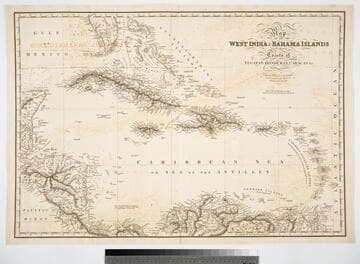
Map of the West India & Bahama Islands with the adjacent Coasts of Yucatan, Honduras, Caracas, &c
Visual Materials
Prime meridian: GM. Relief: hachures. Graphic Scale: Miles. Projection: Cylindrical. Printing Process: Copper engraving. Verso Text: MS note: 725.
093:725 M

Map of the West India & Bahama Islands with the adjacent Coasts of Yucatan, Honduras, Caracas, &c
Visual Materials
See also 105:957 for a later version. Prime meridian: GM. Relief: hachures. Graphic Scale: Miles. Projection: Cylindrical. Printing Process: Copper engraving. Verso Text: MS note: 956.
105:956 M

Map of the West India & Bahama Islands with the adjacent Coasts of Yucatan, Honduras, Caracas, &c
Visual Materials
See also 105:956 for an earlier version. Prime meridian: GM. Relief: hachures. Graphic Scale: Miles. Projection: Cylindrical. Printing Process: Copper engraving. Verso Text: MS note: 957.
105:957 M

West India Islands And Adjacent Coasts of the United States, Mexico, Guatimala & Columbia
Visual Materials
Kashnor dates as ca. 1831. Submap: Island of Jamaica. "LXIV (upper left)" Prime meridian: GM. Relief: pictorial & hachures. Projection: Cylindrical. Printing Process: Copper engraving. Other Features: Sub-maps. Verso Text: MS notes: 974 West India Islands 64.
105:974 M