Visual Materials
A map of the western parts of the colony of Virginia
You might also be interested in
Image not available
Accurate Map of Louisiana, and the Territory in Dispute between the English & French
Visual Materials
Kashnor notes, "Includes parts of Virginia, North and South Carolina, Georgia and Florida." Kashnor dates as ca. 1755. RLIN record suggests 1761. RLIN record covers a photocopy but is included to add data of appeared in information. MS note: 421 (on backing). Prime meridian: London. Relief: pictorial. Graphic Scale: Miles. Projection: Pseudocylindrical. Printing Process: Copper engraving. Verso Text: MS note: 421 (on backing).
093:421 S
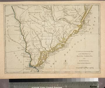
New and Accurate Map of the Chief Parts of South Carolina, and Georgia, From the Best Authorities
Visual Materials
Kashnor notes, "Published during the Revolution, this map shows the main roads in both provinces." This map duplicates 093:075S. Map is trimmed to neatline all sides. District and Township lines marked. MS note: 76 (on backing). Prime meridian: London. Relief: no. Graphic Scale: Miles. Projection: Cylindrical. Printing Process: Copper engraving. Verso Text: MS note: 76 (on backing).
093:076 S

A New and Accurate Map of Virginia, and Part of Maryland and Pennsylvania
Visual Materials
Kashnor notes, "This takes in also the Delaware Counties and part of New Jersey. A scarce map, issued during the Revolution." "Jno. Lodge Sculp." Appeared in information from RLIN record. MS note: 515 (on backing). Prime meridian: London. Relief: pictorial. Projection: Mercator. Printing Process: Copper engraving.
105:515 S

A map of Connecticut and Rhode Island, with Long Island Sound, &c
Visual Materials
Kashnor notes, "An interesting old map, published during the American Revolution, showing the old roads and towns." Kashnor dates c.1776. RLIN record notes publication in Gentleman's Magazine, November, 1776, vol. 46. Notes copper mines shown near Simsbury, CT. Place of publication assumed: Gentleman's Magazine is a London publication. MS note: 90 (on backing). Prime meridian: London. Relief: pictorial. Graphic Scale: Miles. Projection: Plane. Printing Process: Copper engraving. Verso Text: MS note: 90 (on backing).
093:090 S
Image not available
North America Sheet XII. Georgia, with parts of North & South Carolina, Tennessee, Alabama, and Florida
Visual Materials
Kashnor notes that the publisher information has been trimmed from the lower border, supplies the information that the publisher was Baldwin & Cradock, publication date 29 Sept. 1834. MS note: 396 (on backing) . Prime meridian: London. Relief: hachures. Projection: Pseudocylindrical. Printing Process: Engraving. Verso Text: MS note: 396 (on backing) .
093:396 S
Image not available
A New Map of North America from the Latest Discoveries. 1763
Visual Materials
Kashnor notes, "A good map of the far west to the Lake of the Woods, and locating Fort St. Charles and Fort St. Pierre. Shows the old boundaries of Carolina, Virginia, and New England reaching beyond the Mississippi." MS note: 524 (on backing). Prime meridian: London. Relief: pictorial. Projection: Mercator. Printing Process: Copper engraving.
105:524 S