Rare Books
Wallis's guide for strangers : through London, and its environs
You might also be interested in

St. Lucia; Done from Surveys and Observations made by the English whilst in their Possession. by Thomad Jefferys Geographer to the King. Published by Laurie & Whittle, No. 53 Fleet Street London as the Act directs 12th May, 1794
Visual Materials
Submap: Plan of Carenage.. Prime meridian: London. Relief: hachures. Graphic Scale: Leagues. Projection: Cylindrical. Printing Process: Copper engraving. Other Features: Sub-maps.
093:830 M
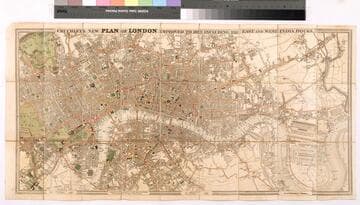
Cruchley's new plan of London improved to 1829 including the East and West India Docks
Rare Books
In case, with paper label titled: Cruchley's new plan of London in miniature, improved to 1829...shewing the new improvements in Saint James's Park, Hyde Park, and Regent's Park, with East and West India docks, the London docks, and the new docks of Saint Catharine's...Engraved and pub. by Cruchley...(from Arrowsmith's). Prime meridian: GM. Relief: no. Graphic Scale: Miles. Projection: Cylindrical. Printing Process: Copper engraving. Verso Text: MS note: 421131.
421131

Bowles's New One-Sheet Map of Jamaica, Divided into its Parishes, &c. from the Actual Surveys of Sheffield and others
Visual Materials
Submap: General plan of Port Royal [showing before and after earthquake dimensions].. Prime meridian: London. Relief: pictorial. Graphic Scale: Miles. Projection: Cylindrical. Printing Process: Copper engraving. Other Features: Sub-maps. Verso Text: MS note: 788.
093:788 M
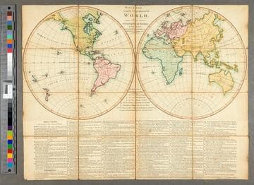
Wallis's complete voyage round the world : a new geographical pastime. London
Rare Books
Game involving spinning a totem numbered 1-8 on its sides, the player moving the number of spaces indicated. There are traps where the player forfeits a turn when landed upon. Watch out for Port Jackson (Sydney) where a player is detained two turns to view the convict colony. Directions for playing the game. Prime meridian: GM. Relief: no. Projection: Dual Hemisphere. Printing Process: Lithography.
47211

New & Accurate Map of the Island of Jamaica Divided into its Parishes, Containing theTowns, Plantations, Forts, Capes, Bays, &c. from all the Surveys made there of the Year 1755
Visual Materials
Two submaps. Submap: The Harbour of Port-Royal; Particular Plan of Port Royal before the Earthquake in 1692 and after the present year of 1755. . Prime meridian: London. Relief: pictorial. Graphic Scale: Miles. Projection: Cylindrical. Printing Process: Copper engraving. Other Features: Sub-maps.
093:800 M

Geological map of England and Wales (with all the railways) according to the most recent researches by Sir Roderick I. Murchison, D.C.L. &c. &c. &c. Director General of the Geological Survey of Great Britain & Ireland
Rare Books
Kirkpatrick Catalogue entry: "2524 Murchison, Sir R. I. Geological Map of England and Wales ... according to the most recent researches; fourth edition. London, Edward Stanford, 1858. 1 sheet. [see cabinet]."Alternate title from cover. Publisher's advertisement on verso and pastedown. Colorful map showing the depositary and igneous rocks throughout England and Wales. Prime meridian: GM. Relief: no. Projection: Cylindrical. Printing Process: Copper engraving. Verso Text: Ms note: R.B. 11491y. Stamps: Kensington Public Libraries..
623697