Rare Books
Charte von der Herschaft Jever : Nach astronomischen Bestimmungen, und im Lande selbst gemachten Zeichnungen, auch andren Hülfsmitteln entworfen / von F.L. Güssefeld
You might also be interested in
Image not available
Charte von America : nach astronomischen Bestimmungen, den neuesten Nachrichten und Charten / entworfen von F.L. Güfsefeld [sic]
Visual Materials
Kashnor notes, "Locates Drake's Haven, San Bernardino, Monterey, Juan de Fuca Strait, Nootka, and a good coastline to Alaska." Prime meridian: Ferro. Relief: pictorial. Projection: Azimuthal. Watermark: Anchor? Figures?. Printing Process: Copper engraving. Verso Text: MS note: 227.
105:227 M

Martinico, one of the Caribbee Islands, in the West Indies; Subject to the French. according to Observations of Mr. Houel Engineer, by Thos. Jefferys, Geographer ti His Royal Highness the Prince
Visual Materials
Kashnor dates ca. 1760. Cartouche: framed with sugar cane. MS note: 813. Prime meridian: Ferro, London. Relief: hachures. Graphic Scale: Miles, leagues. Projection: Cylindrical. Watermark: Crowned fluer-di-lis over IVC. Printing Process: Copper engraving. Other Features: Cartouche. Verso Text: M
093:813 S
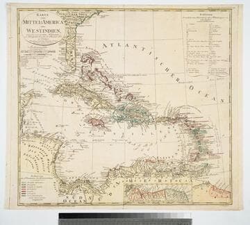
Karte von mittel-America oder Westindien : entworfen nach bewährten Hülfsmitteln von Fridr. Gottlieb Canzler, der Philosoph. Dr. zu Göttingen
Visual Materials
Submap: Coast of Guiana, "Nebenkarte von der Küste Guiana in S. America, nach Hartsinck." Prime meridian: Ferro, London. Relief: pictorial. Graphic Scale: Leagues, miles. Projection: Azimuthal. Watermark: Two devices. Printing Process: Copper engraving. Verso Text: MS note: 893.
105:893 M

Martinico, Done from Actual Surveys and Observations, made by English Engineers whilst the Island was in their Possession, by Thomas Jefferys Geographer to the King
Visual Materials
Submap: Cul de Sac Royal. "VIII (upper right)" Prime meridian: Ferro. Relief: hachures. Graphic Scale: Leagues. Projection: Plane. Watermark: Crowned fleur-di-lis VI. Printing Process: Copper engraving. Other Features: Sub-maps. Verso Text: MS notes: 507 16.
105:507 M
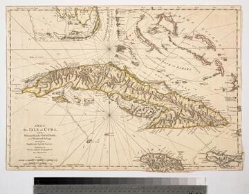
Map of the Isle of Cuba, with the Bahama Islands, Gulf of Florida, and Windward Passage: Drawn from English and Spanish Surveys. Engraved by Thomas Jefferys, Geographer to His Majesty
Visual Materials
Prime meridian: London, Ferro. Relief: pictorial. Graphic Scale: Miles, leagues. Projection: Cylindrical. Watermark: Fleur-di-lis on coat of arms. Printing Process: Copper engraving.
093:754 S
Image not available
Carte Générale de l'Amérique 1754
Visual Materials
Kashnor notes, "Indicates the coast of California to the Juan de Fuca Strait." Kashnor locates publication as Paris, author as Jean Palariest. MS note: 12 Jean Palariat. Prime meridian: Ferro. Relief: pictorial. Graphic Scale: Miles (naut), leagues. Projection: Pseudocylindrical. Watermark: Crowned fluer-di-lis IV. Printing Process: Copper engraving. Other Features: Cartouche. Verso Text: MS notes: 168 12.
093:168 M