Rare Books
Map of the silver mines of Nevada
You might also be interested in
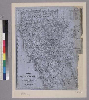
Map of the Mining Region of California. 1854
Rare Books
Image of a map from Oregon border to Monterey and Tulare Counties, and from the Pacific Coast to the Utah desert. In the upper right corner is a "Table of Distances from the Capital." On the right side is a list of the population of California and several cities. "Drawn & Compiled by Geo H. Baker. Published by Barber & Baker, Sacramento, Cal. Fishbourne's Lithog. San Francisco, Cal."--text, below map title. "Entered According to Act of Congress, in the Year 1854, by Barber & Baker, in the Clerks Office of the District Court of the United States, for the Northern District of California. Fishbourne Lithogy. California."--text, below image. "Noisy Carriers, San Francisco."--stamped text, above image. Paper color: blue.
48052:060
Image not available
Wheeler's Topographical Map of San Francisco County
Rare Books
San Francisco County extends south to Santa Clara and Santa Cruz Counties. "Entered according to Act of Congress in the year 1855 by F. Marriott & Alfred Wheeler in the Clerks Office of the District Court of the Northern District of California." " Surveyed by Vitus Wackenreuder for Alfred Wheeler." "Engraved by W. E. Goldsmith & E. Moody San Francisco." Includes inset : Synopsis of County of San Francisco. Land grants shown. MS note: 12066. Prime meridian: GM. Relief: hachures. Graphic Scale: Miles. Projection: Cylindrical. Printing Process: Copper engraving.
12066
Image not available
Geo. W. Cartwright map of College Avenue in Beekman Town, New York
Manuscripts
Map of College Avenue in Beekman Town, New York, likely drawn by civil engineer and surveyor George W. Cartwright. The heading reads, "[-----] College Avenue Beekman Town as Released to the Town of Mount Pleasant by [M----?] Cornelia Beekman showing the encroachment on same as shaded pink," by Geo. W.C. Draft in pencil.
mssHM 80246
Image not available
Map of the City and County of San Francisco : carefully compiled from recent surveys, including all the new additions of Cities, Towns, and Villas delineating the lines of Ranchos, Private Claims, Water Works, Railroads, &c &c
Rare Books
"Lith Britton & Rey S.F. Entered According to Act of Congress in the year 1863 by Frederick Marriott in the Clerks Office of the U.S. District Court of Northern California." Prime meridian: GM. Relief: no. Graphic Scale: Miles. Projection: Plane. Printing Process: Lithography.
2206
Image not available
Map of the city of San Francisco, full and complete to the present date
Rare Books
Showing land which was filled and land to be filled. "Compiled by Wm. M. Eddy. City Surveyor. February 15th, 1852." "Engraved by Edwin Moody. John B. Brady delr." "Entered according to Act of Congress, in the year 1854 by Wm. M. Eddy, in the Clerks Office of the District Court of the United States for the Northern District of California." Prime meridian: GM. Relief: no. Graphic Scale: Varas, feet. Projection: Plane. Printing Process: Lithography.
137123
Image not available
Map of Delaware Co. New York From actual survey by Jay Gould
Visual Materials
Kashnor notes, "Contains minor maps of a number of towns (listed) and views of prominent homes and churches (listed)." Submaps of 24 towns with directories. Vignettes of nineteen landmarks and references.. "Entered according to act of Congress in the year 1856 by Robert Pearsall Smith in the clerks office of the District Court of the Eastern District of Pennsylvania." Relief: hachures. Graphic Scale: Miles, furlongs. Projection: Plane. Printing Process: Lithography. Other Features: VignettesSub-maps.
105:580 M