Visual Materials
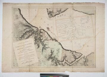
A Plan of the Posts of York and Gloucester in the Province of Virginia, Established by His Majesty's Army under the Command of Lieut. General Earl Cornwallis, together with The Attacks and Operations of the American and French Forces, Commanded by General Washington and the Count of Rochambeau, Which Terminated in the Surrender of the said Posts and Army, on the 17th of October 1781. / Surveyed by Captn. Fage of the Royal Artillery

You might also be interested in
A Plan of the Posts of York and Gloucester in the Province of Virginia, Established by His Majesty's Army under the Command of Lieut. General Earl Cornwallis, together with The Attacks and Operations of the American & French Forces Commanded by General Washington and the Count of Rochambeau, Which Terminated in the Surrender of the said Posts and Army on the 17th of October 1781 / Surveyed by Captn. Fage of the Royal Artillery
Rare Books
An important map with no attribution but possibly by William Faden. An overlay shows the positions of the British forces on September 28th and 29th some two weeks prior to the surrender. The main map shows the British forces trapped in York itself and the redoubts and batteries set up by the American and French forces. The Charon is shown in flames in York harbor and French ships sit off Gloucester. The bulk of the French fleet is not shown, but blockaded the mouth of Chesapeake Bay, trapping the British army who then surrendered ending the American Revolutionary War. Submap: Overlay, showing British positions on Sept 28-29.. Prime meridian: Gm. Relief: shaded, hachures. Graphic Scale: Feet. Projection: Plane. Printing Process: Copper engraving. Other Features: Sub-maps.
268097

Map exhibiting the Frontiers of Canada and the United States, intended to illustrate The Operation of the British & American Armies
Visual Materials
Kashnor notes, "A scarce map issued during the War of 1812." Submap of East Coast from St. Lawrence River to Chesapeake Bay. Submap: Sketch of the Coast of North America from the River St. Lawrence, to Chesapeake Bay. MS notes at top give positions of British and "Enemy" forces on 30th Oct (year uncertain).. Prime meridian: GM. Relief: no. Graphic Scale: Miles. Projection: Azimuthal. Printing Process: Engraving. Other Features: Sub-maps. Verso Text: CANADA.
093:245 M

Map for the Interior Travels through America, delineating the March of the Army
Visual Materials
Kashnor notes, "A lithograph from the original map. Shows the coast from Casco Bay to James River, and indicates the line of march of the British forces, and the extent of parole allowed to British and German officers held prizoner by the Americans." Kashnor dates at [circa 1780] but more probably this early lithograph was made in the early 1800's. Some distortion through transfer from original map. Original engraver and appeared in information from RLIN record. Kashnor has this item numbered as 105*. Lithographed copy does not have colors of original map, see RLIN record.. Prime meridian: London. Relief: pictorial. Graphic Scale: Miles, statute. Projection: Cylindrical. Printing Process: Lithography. Verso Text: MS note: 105.
105:105 M
Image not available
A New Map of Virginia Mary=Land And the Improved Parts of Penn=sylvania & New=Jersey
Visual Materials
Kashnor notes, "Shows the coast from Perth to the entrance of the Bay of Chesapeake - a fine clear old map. This is the earliest issue of the Senex map before his name was engraved in the cartouche." See also 105:822 with additional information in cartouche. Cartouche with tobacco.. Relief: pictorial. Graphic Scale: Miles (leagues). Projection: Plane. Watermark: HD. Printing Process: Copper engraving. Other Features: Cartouche. References: Tooley (Amer.) p.104; Phillips M. p.980.. Verso Text: MS note: 821.
105:821 M
Image not available
A New and Accurate Map of the English Empire in North America: Representing their Rightful Claim as confirmed by Charters, and the formal Surrender of their Indian Friends; Likewise the Encroachment of the French, with the several Forts thery have unjustly erected therein. By a Society of Anti-Gallicans
Visual Materials
Kashnor notes, "Indicates by the use of different colours, the territory in dispute, which includes the greater part of the continent of North America, and shows the boundaries of the Carolinas, Georgia, and Virginia reaching far west beyond the Mississippi." Contains submap. Submap of extended territory, Hudson's Bay to South America.. Prime meridian: London, Ferro. Relief: pictorial. Projection: Pseudocylindrical. Watermark: Fleur-di-lis on shield W. Printing Process: Copper engraving. Other Features: Sub-maps. References: McCorkle 755.38. Verso Text: MS note: 667.
105:667 M
Image not available
Map of the Oregon Territory / by the U. S. Ex. Ex. Charles Wilkes Esqr. Commander 1841
Visual Materials
Kashnor notes, "An exceedingly rare map issued in England during the Oregon dispute. A note states that the northern part of the map contains the latest information of the Hudson's Bay Company, and the eastern side of the Rockies that of Lieut. Fremont. The northern boundary of the territory is at Fort Simpson on Dixon's Entrance." Contains submap of the Columbia River. EX. Ex. is "Exploring Expedition." Submap: Columbia River reduced from a survey by the U. S. Ex. Ex. 1841. Prime meridian: GM. Relief: hachures. Graphic Scale: Miles. Projection: Azimuthal. Printing Process: Copper engraving. Other Features: Sub-maps. Verso Text: Ms note: 706 two sections with marbled end paper..
105:706 M