Visual Materials
Plan of the Colorado Rocks, near the West end of Cuba. ; Plan of the City and Harbour of the Havana

You might also be interested in

Authentic Plan of the Tolwn and Harbour of Cap-Francois in the Isle of St. Domingo. By Thomas Jefferys Geographer to His Royal Highness the Prince of Wales
Visual Materials
MS note: 779. Relief: hachures. Graphic Scale: Fathoms. Projection: Plane. Watermark: Crowned fleur-de-lis over LVG VI. Printing Process: Copper engraving.
093:779 M
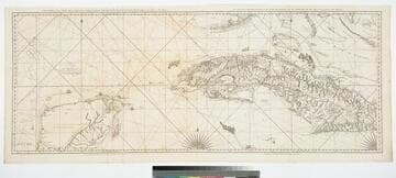
The Coast of Yucatan from Campeche to Ascension Bay with the West End of Cuba, by Thos. Jefferys Geographer to His Majesty
Visual Materials
Two maps joined to make one sheet. Prime meridian: London. Relief: pictorial & hachures. Graphic Scale: Leagues. Projection: Cylindrical. Watermark: Crowned fleur-de-lis LA. Printing Process: Copper engraving. Verso Text: MS note: 905.
105:905 M

A New and Correct Plan of the City and Harbour of Havana on the Island of Cuba with the Depths of Water, Sands, and Rocks in it from the best and latest surveys by Pr. Chassereau Architect 1739
Visual Materials
Vignette: Harbor of Havana. Cartouche: wreath with figures.. Relief: pictorial. Graphic Scale: Miles, furlongs. Projection: Plane. Printing Process: Copper engraving. Other Features: Vignettes. Verso Text: MS note: 383.
105:383 M

Plan of Guantanimo, called by the English Cumberland Harbour. ; Plan of the City of St. Jago de Cuba
Visual Materials
Kashnor dates as ca. 1755. MS notes: 64 65 (upper right) Q23. Relief: hachures. Graphic Scale: miles. Projection: Plane. Watermark: IV. Printing Process: Copper engraving. Verso Text: MS note: 374.
105:374 M
Image not available
An Exact Plan of Charles-town-Bar and Harbour : From an actual survey ; With the attack of Fort Sulivan, on the 28th of June 1776, By His Majesty's Squadron, Commanded by Sir Peter Parker
Rare Books
Prime meridian: GM. Relief: no. Graphic Scale: Miles. Projection: Cylindrical. Watermark: Crowned shield VI. Printing Process: Copper engraving.
295805

New Map of the West Indian Islands, as they are Possessed by the European Powers
Visual Materials
Kashnor ontes, "Indicates the English, Dutch, French, and Spanish possessions." Cartouche: branches.. "Drawn from the most Recent Authorities." Prime meridian: London. Relief: pictorial. Graphic Scale: Leagues. Projection: Cylindrical. Watermark: Crowned fleur-di-lis VI. Printing Process: Copper engraving. Other Features: Cartouche. Verso Text: MS note: 966.
105:966 M