Manuscripts
Map of a tract of land in the city of Los Angeles

You might also be interested in
Map of a tract of land in the city of Los Angeles
Manuscripts
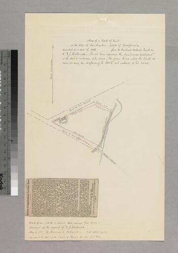
Pg. 8 of document, "W.J. Broderick. Lot of land on the east side of Los Angeles River..." shows roads to San Diego & San Gabriel, structures, courses, distances; attached is newspaper clipping: "Notice of Application for City Deed," dated June 7th, 1883. Alt. title supplied by cataloger.
mssSolano SR_Box_26(41).01A
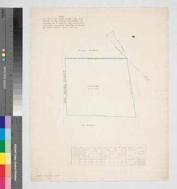
Map of a tract of Land in the City and County of Los Angeles California.; belonging to F. Sabichi Esq
Manuscripts
East side San Pedro St.; table of courses, distances; red, black & blue inks; Orange orchard & Jos Waibel property adjacent. . Alt title supplied by cataloger.
mssSolano SR_Map_0439.01

Map of the Subdivision of a Lot of Land granted by the City of Los Angeles to Hiram McLaughlin.; sale to P. Beaudry
Manuscripts
Showing numbered lots, courses, distances along New High Street; Jail Lot of Benjamin S. Eaton Sketches on verso. Alt. title supplied by cataloger.
mssSolano SR_Box_26(27).07

Map of a City Lot belonging to the Catholic Church surveyed at the request of Col. G.W.Gitchel
Manuscripts
Within folder, "Lot on Main Street," pg. 5 [marked p. no. 6] of document, "Los Angeles City April 24, 1871, The R.R. Bishop Amat requests..." showing church lot with courses, distances, structures, posts; outlined in color . Alt. title supplied by cataloger.
mssSolano SR_Box_26(11).09
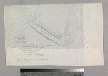
Tract of Land donated to the City by Bors
Manuscripts
P. 3 of document, " Theodore Bors. tract of land on East side of Los Angeles River..." Copied from the city archives: for the purpose of widening the road to San Gabriel at the crossing of the river and up the hill eastwardly: San Gabriel Road & the Los Angeles River; minor color highlights; courses, distances; small table of boundary data. Alt. title supplied by cataloger.
mssSolano SR_Box_26(35).02

Map of a Lot of land
Manuscripts
P. 2 of pinned document, "Dr. Joseph Kurtz. Lot on West side of Main Street..." Showing courses, distances, parcel owners along Main at First St.; color outlining. Alt. title supplied by cataloger.
mssSolano SR_Box_29(20).01