Manuscripts
Profile of the stream of water in the Arroyo Seco running through the land of F.P. Ramirez & J.S. Shepherd

You might also be interested in
Arroyo Seco - sketch maps
Manuscripts
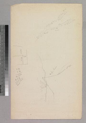
Verso of page entitled, "Jesse D. Hunter," showing surface details, courses, distances, markers. Title supplied by cataloger.
mssSolano SR_Box_26(17).02

Arroyo Seco - meanders of Arroyo Seco
Manuscripts
P. 2 of document, "Alfred B. Chapman vs. Fernando Sepulveda... F.P. Ramirez..." T. 1 S.R. 13 W. section 12, parcel owners, courses, distances, surface details, acreage. Title supplied by cataloger.
mssSolano SR_Box_26(17).01

Arroyo Seco - copied from Township plat in the U.S. Land Office
Manuscripts
Inserted sheet in "Jesse D. Hunter" document, with table of meander data; sec. 11 noted, markers, courses, distances; re-surveyed in 1869 by Wm. P. Reynolds; red pencil notations. Title supplied by cataloger.
mssSolano SR_Box_26(17).03

Boyle Heights Arroyo
Manuscripts
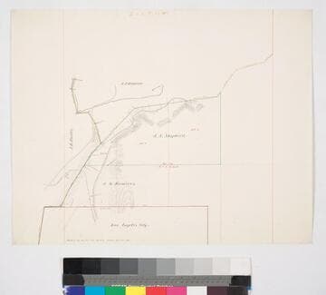
Structures; topographic detail: hachures, bearings, distances, parcel owners. Alt title supplied by cataloger.
mssSolano SR_Map_0370

Description. Commencing at cor. to Sections T 2 S.R. 13 W
Manuscripts
Showing parcel owners, courses, distances, acreage. Alt. title supplied by cataloger.
mssSolano SR_Box_26(40).04
Los Angeles County public lands : J.S. Shepherd and J.M. Ramirez parcels
Manuscripts
Bordered by City of Los Angeles. Highland Park along the Arroyo Seco, sec. 12, T. 1S. R. 13W. S.B.M., showing structures, surface details - extensive hachures, vegetation; parcel owners; color highlighting. Title supplied by cataloger.
mssSolano SR_Map_0770