Manuscripts
Los Angeles County public lands : Louis Sentous parcel

You might also be interested in

Los Angeles County public lands SW of Los Angeles : Sec. 17-22, T.2S. R. 14W. S.B.M
Manuscripts
Boundaries with Ranchos Aguaje de la Centinela, Sausal Redondo, la Ballona, and Ciénega ó Paso de la Tijera*. On printed Township Map grid with Meanders and survey data tables; notation re: railroad add sections; shows parcel owners; color highlighting. Title supplied by cataloger.
mssSolano SR_Map_0767.01

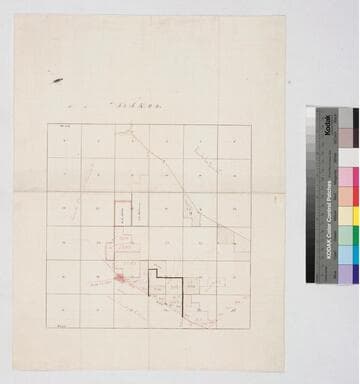
Los Angeles County public lands : sketch map
Manuscripts
Boundaries of Ranchos Paso de Bartolo, Santa Gertrudes, La Habra, and La Puente. Detailing within T.2 S.R.11 W; color highlighting (water color), courses, parcel numbered grid; pencil calculations. Title supplied by cataloger.
mssSolano SR_Map_0763.03

Centinela Los Angeles County, Cal
Manuscripts
Rancho Aguaje de la Centinela. Subdivision map, Sec. 31-33, T.2 S.R.14 W. S.B.M., and sec. 4-9, 16-18, T.3S. R.14W. S.B.M., showing surface detail, hachures; color highlighting; parks, orange grove; extensive survey notes: "resurveyed by Henry Stevenson 1878. Joseph Smith". [See also Maps 3, 1-2]
mssSolano SR_Map_0752
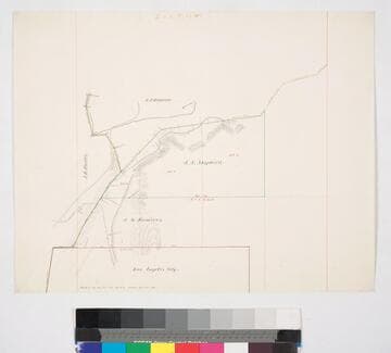
Los Angeles County public lands : J.S. Shepherd and J.M. Ramirez parcels
Manuscripts
Bordered by City of Los Angeles. Highland Park along the Arroyo Seco, sec. 12, T. 1S. R. 13W. S.B.M., showing structures, surface details - extensive hachures, vegetation; parcel owners; color highlighting. Title supplied by cataloger.
mssSolano SR_Map_0770
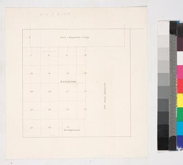
Los Angeles County public lands : T.2S. R. 13W. S.B.M
Manuscripts
Bordered by Ranchos San Antonio & Tajauta, Los Angeles City. Hand drawn township grid in red & black inks; shows 1876 charter boundary. Title supplied by cataloger.
mssSolano SR_Map_0768
Los Angeles County public lands : T.2 S.R.11 W
Manuscripts
Bordered by Ranchos La Puente, Paso de Bartolo. Color highlighting, acreage, parcel numbers, hachures, owners indicated on very faint graph paper. Verso: faint writing - "West half of S.W. 1/4 of Sec. 8...T.2 S.R.11 W". Title supplied by cataloger.
mssSolano SR_Map_0763.04