Manuscripts
Los Angeles County public lands : T.2 S.R.11 W

You might also be interested in

Los Angeles County public lands : T.2 S.R.11 W. front
Manuscripts
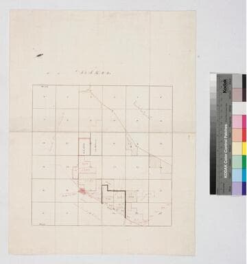
Bordering Rancho La Puente. On printed township grid: very detailed hachures; color highlighted parcels of Childs, Hellman & Rulo with survey notations. Verso: sketch in pencil. Title supplied by cataloger.
mssSolano SR_Map_0763.07A

Los Angeles County public lands : T.2 S.R.11 W. back
Manuscripts
Bordering Rancho La Puente. On printed township grid: very detailed hachures; color highlighted parcels of Childs, Hellman & Rulo with survey notations. Verso: sketch in pencil. Title supplied by cataloger.
mssSolano SR_Map_0763.07B

Los Angeles County public lands : T.2 S.R.11 W
Manuscripts
Rancho Paso de Bartolo. On township grid: hachures, color highlighted parcels of Childs, Hellman, Wiseman, Qualey, and Passons; pencil annotations. Title supplied by cataloger.
mssSolano SR_Map_0763.05
Los Angeles County public lands : T.2 S.R.11 W
Manuscripts
Bordered by Ranchos La Puente, Paso de Bartolo. Color highlighting, acreage, parcel numbers, hachures, owners indicated on very faint graph paper. Verso: faint writing - "West half of S.W. 1/4 of Sec. 8...T.2 S.R.11 W". Title supplied by cataloger.
mssSolano SR_Map_0763.04
Los Angeles County public lands : T.2S. R. 13W. S.B.M
Manuscripts
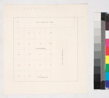
Bordered by Ranchos San Antonio & Tajauta, Los Angeles City. Hand drawn township grid in red & black inks; shows 1876 charter boundary. Title supplied by cataloger.
mssSolano SR_Map_0768

Los Angeles County public lands SW of Los Angeles : Sec. 17-22, T.2S. R. 14W. S.B.M
Manuscripts
Boundaries with Ranchos Aguaje de la Centinela, Sausal Redondo, la Ballona, and Ciénega ó Paso de la Tijera*. On printed Township Map grid with Meanders and survey data tables; notation re: railroad add sections; shows parcel owners; color highlighting. Title supplied by cataloger.
mssSolano SR_Map_0767.01