Manuscripts
Kern County Public lands : T.32 S. R. 34 E. Mt. Diablo Meridian

You might also be interested in

Kern County public lands : T.28 S.R. 37 E., Mt. Diablo Meridian
Manuscripts
On printed township grid: showing acreages, water courses, surface detail - dry ravine, dry slough. Verified copy by Brewster, surveyor general. Title supplied by cataloger.
mssSolano SR_Map_0758

Inyo County aggregate area of public lands : T.24 S.R. 40 E., Mt. Diablo Meridian
Manuscripts
On printed township grid: showing acreages, water courses, surface detail: saline prairies, salt lake, dry creeks. Verified copy by Brewster, surveyor general. Title supplied by cataloger.
mssSolano SR_Map_0757

Kern County Public lands : T.29 S.R.40 E., Mt. Diablo Meridian
Manuscripts
On printed township grid: showing acreages, water courses, hachures: "Steep, abrupt mountains, Rough Hills," dry creek. Verified copy by Brewster, surveyor general. Title supplied by cataloger.
mssSolano SR_Map_0760
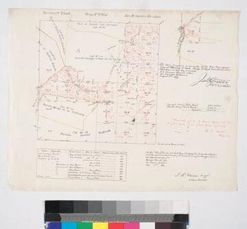
Los Angeles County public lands : T.2 S. R. 14W., S.B.M
Manuscripts
Showing parts of Ranchos Ballona, Rincon de Bueyes, Aguaje de la Centinela, Sausal Redondo, Las Cienegas; public lands. showing acreages and surface detail, based on surveys of 1853-1871, with diagram of T.2 S.R. 14 W.; with color highlighting, section numbers, courses, distances, lots of notations in red ink; table of surveying history; minor surface details. Title supplied by cataloger.
mssSolano SR_Map_0766

Elizabeth Lake : Public lands T.7 N. R.14 W. S.B.M
Manuscripts
On printed township grid showing structures, surface detail, notes re: parcel owners & corresponding courses. Paper watermark: Hurlbut Paper Co. Title supplied by cataloger.
mssSolano SR_Map_0755.01
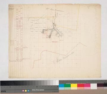
Rancho San Francisco: parcels beyond southern boundary in sec. 4-11, 14-17, T.3N. R.16W. S.B.M
Manuscripts
Rancho San Fernando to the south Indicates names of owners, surface detail in hachures; waterways; color highlights On printed township grid; table with courses & boundary data. Title supplied by cataloger.
mssSolano SR_Map_0145