Manuscripts
Solano Tract No. 2

You might also be interested in
Solano Tract No. 2
Manuscripts
Copy of previous blueprint with lots numbered or marked "sold" in red, plus note: "Building Restriction on Solano Ave $1200 and on balance of tract $1000.00. Buildings 25 ft. fr. street line". Black ink annotation across the middle of Effie Street with acreage numbers for parcels. Verso: stamp: Olin G. McWain Blue Printing, Byrne Bldg. Los Angeles, Cal.. [see also Map 743]. Alt title supplied by cataloger.
mssSolano SR_Map_0748.04

Solano Tract No. 2
Manuscripts
Copy of previous blueprint with possible water body (reservoir?) drawn in pencil across Effie Street; some lots with red coloring. Verso: Solano Tract; also Stamp: Olin G. McWain Blue Printing, Byrne Bldg. Los Angeles, Cal., plus pencil notations . [see also Map 743]. Alt title supplied by cataloger.
mssSolano SR_Map_0748.02

Solano Tract No. 2
Manuscripts
Copy of previous maps with some lots filled in with pink coloring; pencil calculations. Verso: stamp: Olin G. McWain Blue Printing, Byrne Bldg. Los Angeles, Cal.. [see also Map 743]. Alt title supplied by cataloger.
mssSolano SR_Map_0748.05

Solano Tract No. 2
Manuscripts
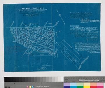
Being a subdivision of a portion of Lot 6 and all of Lot 7, Block 46 Hancock's Survey of Donation Lots. Notarized remarks re: subdivision with witnesses' signatures; some lots with red coloring. Verso: Solano Tract No. 2 recorded in Book 4 page 17 of Maps in the office of the co. recorder of said county. Stamp: Olin G. McWain Blue Printing, Byrne Bldg. Los Angeles, Cal., plus pencil notations . [see also Map 743]. Alt title supplied by cataloger.
mssSolano SR_Map_0748.01

Map of Elysian Park Tract, Being a Re-subdivision of the Solano Tract No. 2
Manuscripts
Park Row and Elysian Park to Effie St., Yuba St. to Yolo Dr.; certification notes and approval; one lot is hand colored . Verso: stamp: Olin G. McWain Blue Printing, Byrne Bldg. Los Angeles, Cal.; in pencil: "insurance". [see also Maps 743, 748]. Alt title supplied by cataloger.
mssSolano SR_Map_0749.01
Image not available
Map of northern portion of the Rancho Ex Mission de San Fernando, Los Angeles Co., Cal
Visual Materials
Old shelf number: eph J5-18(1). This map divides the interests of Porter Land & Water Co., George K. Porter, and B.F. Porter by hand colored boundaries. Shows Catalina Pico and Rinaldi ranch holdings, the towns of "Fernando" and "Chatsworth-Park." MS notes on property use and disposition. Olin G. McWain, whose stamp is on the verso, did not start working as a blueprint and map printer until 1898, based on Los Angeles directories of the time; the company continued until at least 1920 in the Byrne Building. Prime meridian: GM. Relief: no. Graphic Scale: Miles. Projection: Cylindrical. Printing Process: Blue print copy. Verso Text: MS notes: Eph J5-18(1). Blueprint of Rancho Ex Mission de San Fernando, Los Angeles, Calif. Stamp: Olin G. McWain Blue Printing and Map Mounting, Byrne Bldg., Los Angeles, Cal.
ephMPCALIFT0110