Visual Materials
Mexico and Guatemala, shewing the Position of the Mines
You might also be interested in
Image not available
Mexico and Guatemala, shewing the Position of the Mines
Visual Materials
Prime meridian: GM. Relief: hachures. Graphic Scale: Miles. Projection: Pseudocylindrical. Printing Process: Copper engraving. Verso Text: MS note: 676.
093:676 M
Image not available
Battlefields in front of Nashville where the United States Forces commanded by Major General Geo. H. Thomas defeated and routed the Rebel Army under General Hood December 15th & 16th 1864
Visual Materials
Kashnor notes, "Indicates the respective positions of the Federal and Confederate Armies at the different stages of the engagement." Kashnor dates as [1865]. RLIN record notes Washington as place of publication. Relief: hachures. Graphic Scale: Miles. Projection: Plane. Printing Process: Lithography. Verso Text: MS note: 352.
105:352 M
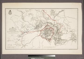
Map illustrating the Siege of Atlanta, GA. by the U.S. Forces, under Command of Maj. Gen. W. T. Sherman from the passage of Peach Tree Creek, July 19th 1864 to the movement upon the Enemy's lines of communication south of Atlanta, August 26, 1864
Visual Materials
Kashnor notes, "Indicates, by red and blue lines, the respective positions of the Federal and Confederate forces." Appeared in info from RLIN record. Shield of Corps of Engineers (?) upper left.. Relief: hachures. Graphic Scale: Miles. Projection: Plane. Printing Process: Lithography. Verso Text: MS notes: 049 348.
105:398 S
Image not available
Map of the Mining District of Mexico
Visual Materials
Kashnor notes [James Wyld] and dates ca. 1830. Tab" Mines of Mexico.. Prime meridian: GM. Relief: hachures. Graphic Scale: Miles. Projection: Cylindrical. Printing Process: Copper engraving. Verso Text: MS note: 675 Two pasted pink diamonds..
093:675 M
Image not available
A New Map of Part of the United States of North America, containing the Carolinas and Georgia. Also the Floridas and part of the Bahama Islands &c. from the Latest Authorities by John Cary, Engraver. 1806
Visual Materials
Kashnor notes, "Shows a good map of the Carolinas." Prime meridian: GM. Relief: pictorial & hachures. Graphic Scale: Miles, leagues. Projection: Pseudocylindrical. Printing Process: Engraving. Verso Text: MS notes: 337 55.
105:337 M
Image not available
A New and Accurate Map of Peru, and the country of the Amazones
Visual Materials
Kashnor notes, "Indicates Parima Lake and the famour city of El Dorado two degrees North of the Equator." Kashnor dates as ca. 1760. RLIN record suggests 1747 as publication data. Cartouche: Decorative shell.. "Drawn from the most authentick French Maps &c. and Regulated by Astronomical Observations. By Eman. Bowen." "No. 118 (lower left)" Prime meridian: London. Relief: pictorial. Graphic Scale: Leagues. Projection: Pseudocylindrical. Printing Process: Copper engraving. Other Features: Cartouche. Verso Text: MS note: 933.
105:933 M