Visual Materials
Boston, and it's Environs
You might also be interested in

New and Accurate Chart of the Harbour of Boston, in New England, in North America
Visual Materials
MS note: 110 (on backing). Relief: hachures. Graphic Scale: Miles. Projection: Plane. Printing Process: Copper engraving.
105:110 S
Image not available
A Map of the Islands of Orleans with the Environs of Quebec
Visual Materials
A duplicate of map 093:329. Kashnor dates as ca. 1760. MS note: 676 (on backing). Relief: hachures. Graphic Scale: Miles. Projection: Plane. Printing Process: Copper engraving.
105:676 S
Image not available
Map of the Islands of Orleans with the Environs of Quebec
Visual Materials
Kashnor links with 093:328 and dates as ca. 1759. See 105:676 for another copy. MS note: 329 (on backing). Relief: hachures. Graphic Scale: Miles. Projection: Plane. Printing Process: Copper engraving. Verso Text: MS note: 329 (on backing).
093:329 S
Image not available
A Map of the Country round Quebec with the Camps of the English & French at the Siege thereof. 1759
Visual Materials
Kashnor dates as [1759]. MS note: 674 (on backing). Relief: hachures. Graphic Scale: Miles. Projection: Plane. Printing Process: Copper engraving. Verso Text: MS note: S 42.
105:675 S
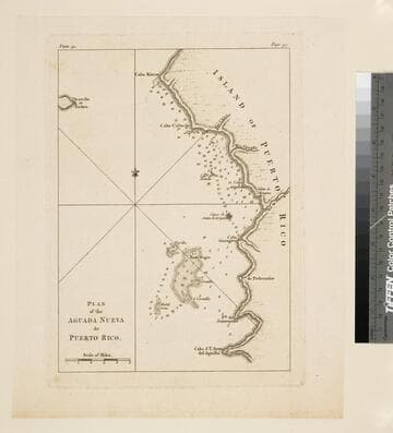
Plan of the Aguada Nueva de Puerto Rico
Visual Materials
Kashnor dates as ca. 1760. "Plate 32. (upper left) Page 97. (upper right)" Ms note: 753 (on backing). Relief: hachures. Graphic Scale: Miles. Projection: Plane. Printing Process: Copper engraving.
105:753 S
Image not available
A Plan of the Seat of the War at and near Quebec, with the Line of Battle
Visual Materials
Kashnor dates [1759]. Submap locates forces. MS note: 680 (on backing). Submap: Troop deployment on the Plain of Abraham.. Relief: hachures. Graphic Scale: Miles. Projection: Plane. Printing Process: Copper engraving.
105:680 S