Manuscripts
Rancho Santa Ana del Chino : T.2S. R.9W. S.B.M

You might also be interested in

Rancho Santa Ana del Chino : T.2S. R.8W. S.B.M
Manuscripts
On printed township grid: covering sections 14-31. Hachures; yellow boundary line, structural landmarks. Title supplied by cataloger.
mssSolano SR_Map_0239.01
![Part of the Rancho Puente in T.2S. R.9W. [S.B.M.]](/_next/image?url=https%3A%2F%2Frail.huntington.org%2FIIIF3%2FImage%2F22APN4KRB7UI%2Ffull%2F%5E360%2C%2F0%2Fdefault.jpg&w=750&q=75)
Part of the Rancho Puente in T.2S. R.9W. [S.B.M.]
Manuscripts
On printed township grid: 36 sections; upper left portion utilized. Inset table with boundary distances
mssSolano SR_Map_0116

Sketch map of T.2N. R.13W. S.B.M
Manuscripts
Rancho La Cañada. Pencil annotations. Township grid: 36 sections Title supplied by cataloger.
mssSolano SR_Map_0034.02
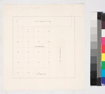
Los Angeles County public lands : T.2S. R. 13W. S.B.M
Manuscripts
Bordered by Ranchos San Antonio & Tajauta, Los Angeles City. Hand drawn township grid in red & black inks; shows 1876 charter boundary. Title supplied by cataloger.
mssSolano SR_Map_0768

Rancho los Coyotes: township map showing parcels and owners in sec.s 16 & 36, T.4S. R.11W. S.B.M
Manuscripts
On printed township grid: T.4S. R.11W.. 36 sections w/ color highlights of landowners J. Belly, J. Shumacher & Co., M. Keller, A. Labory. Title supplied by cataloger.
mssSolano SR_Map_0051

Rancho San Rafael
Manuscripts
Bordered by Ranchos San Pascual, Los Feliz, La Canada; Sierrito Colorado, Burdugo Mtns. On township grid with 36 numbered sections, with river indicated (Los Angeles?). Boundary in color; pencil annotations. Al title supplied by cataloger.
mssSolano SR_Map_0231