Manuscripts
Southern Pacific Rail Road at C.S.S. Co. wharf : entrance to San Pedro Bay

You might also be interested in
Image not available
[Southern Pacific Rail Road at C.S.S. Co. wharf, entrance to San Pedro Bay]
Manuscripts
The collection consists of maps, field books, legal documents, business papers, and diaries related to the work of surveyors George Hansen, Alfred Solano, Sidney B. Reeve, and others. The maps and surveys in the collection are of the city of Los Angeles, Southern California ranchos, and subdivisions of the city of Los Angeles and neighboring towns. The collection contains over maps and sketch maps. Other subjects represented in the collection include: civil engineering, land subdivision, mines and mineral resources, and daily life in Los Angeles and Los Angeles County.
mssSolano

San Pedro Street
Manuscripts
Boundary between Scott and Sainsevain parcels, sec. 4, 9, & 10, T.2S. R. 13W. S.B.M.; color highlighting, survey history ; bearings, distances, other parcel owners indicated. Alt title supplied by cataloger.
mssSolano SR_Map_0485
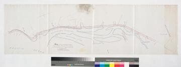
Map of the extension of the Southern Pacific Railroad at Wilmington
Manuscripts
Terminal Island, Pacific Ocean, Rancho San Pedro Hachures, color highlights, structures; Wilmington Channel, sections 8, 18, 19, Goodall Perkins & Co., First Standard South indicated
mssSolano SR_Map_0215
Image not available
[Rancho San Pedro: Rattlesnake Island and inner bay (rail easement?)
Manuscripts
The collection consists of maps, field books, legal documents, business papers, and diaries related to the work of surveyors George Hansen, Alfred Solano, Sidney B. Reeve, and others. The maps and surveys in the collection are of the city of Los Angeles, Southern California ranchos, and subdivisions of the city of Los Angeles and neighboring towns. The collection contains over maps and sketch maps. Other subjects represented in the collection include: civil engineering, land subdivision, mines and mineral resources, and daily life in Los Angeles and Los Angeles County.
mssSolano

Map of State Locations of land claims in the Inner Bay of San Pedro
Manuscripts
Pacific Ocean, Rancho San Pedro For Dominguez heirs, based on surveys of 1870-1884 with extensive notes Featuring Rattlesnake, Mormon, and Dead Man islands Color highlights, hachures; subdivision parcels indicated, U.S. Quarter Master Depot, Front through First streets
mssSolano SR_Map_0219.01
Image not available
[Mrs. Watson's Co. Road, Rancho San Pedro];
Manuscripts
The collection consists of maps, field books, legal documents, business papers, and diaries related to the work of surveyors George Hansen, Alfred Solano, Sidney B. Reeve, and others. The maps and surveys in the collection are of the city of Los Angeles, Southern California ranchos, and subdivisions of the city of Los Angeles and neighboring towns. The collection contains over maps and sketch maps. Other subjects represented in the collection include: civil engineering, land subdivision, mines and mineral resources, and daily life in Los Angeles and Los Angeles County.
mssSolano