Manuscripts
Copy #1 : Map of Lakedale

You might also be interested in

Copy #2 : Map of Lakedale
Manuscripts
Rancho San Pedro. Same as previous map, writing at bottom is larger with a few ink smudges. Featuring Hellman parcel, surface detail, parcel acreage, few hachures & waterways. Var. 14° 45' East. ; #31 on back.. Title supplied by cataloger.
mssSolano SR_Map_0211.03

Map of Lakedale
Manuscripts
Rancho San Pedro. Surveyed by request of I. W. Hellman. Featuring Hellman parcel, surface detail, parcel acreage, few hachures & waterways. Var. 14° 45' East; survey notations on left re: boundaries, Hellman vs. Downey, street courses; other maps referenced; pencil calculations, annotations. ; #33 on back. See also Map 207-5.
mssSolano SR_Map_0211.01

Land in the Rancho San Antonio belonging to J. J. Bullis
Manuscripts
Bordered by San Gabriel River on east. Var. 14° 45' East; red highlights; parcel acreage indicated.
mssSolano SR_Map_0136
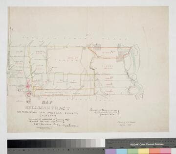
Map of Hellman Tract, San Pedro Ranch
Manuscripts
Bordered by Temple & Gibson, Manuel Dominguez tracts. Surveyed & subdivided in January 1871 at the request . . . of I. W. Hellman, Esq. Surface detail and parcel owners; color highlights, hachures, structures, waterways. Copied by L. C. Wright.
mssSolano SR_Map_0204.01

Rancho San Pedro : S36 - lots XI-XIII and Pedro Dominguez parcel
Manuscripts
Showing courses, distances, surface details, structures, acreage, waterways, posts, parcel owners, S.P.R.R.. Title supplied by cataloger.
mssSolano SR_Box_24(02).03

Map of the Colima Tract
Manuscripts
Showing section numbers, acreage, courses, distances; parcel owners (list with corresponding acreage), structures, surface details, markers. Alt title supplied by cataloger.
mssSolano SR_Box_25(07).01