Manuscripts
Map of Banning's Reservation at New San Pedro

You might also be interested in
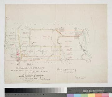
Map of Hellman Tract, San Pedro Ranch
Manuscripts
Bordered by Temple & Gibson, Manuel Dominguez tracts. Surveyed & subdivided in January 1871 at the request . . . of I. W. Hellman, Esq. Surface detail and parcel owners; color highlights, hachures, structures, waterways. Copied by L. C. Wright.
mssSolano SR_Map_0204.01

Land in the Rancho San Antonio belonging to J. J. Bullis
Manuscripts
Bordered by San Gabriel River on east. Var. 14° 45' East; red highlights; parcel acreage indicated.
mssSolano SR_Map_0136
![Map of the land of Alexander Repetto in the Ro. San Antonio and in [sec. 27-29, 32-34] T.1S. R.12W. [S.B.M.]](/_next/image?url=https%3A%2F%2Frail.huntington.org%2FIIIF3%2FImage%2F22APN4KRBNT8%2Ffull%2F%5E360%2C%2F0%2Fdefault.jpg&w=750&q=75)
Map of the land of Alexander Repetto in the Ro. San Antonio and in [sec. 27-29, 32-34] T.1S. R.12W. [S.B.M.]
Manuscripts
Bordered by Ranchos La Merced, La Laguna Mrs. A. B. de Baker; parcel belonging to Abel Stearns, San Gabriel River. Parcels with acreage indicated.
mssSolano SR_Map_0137

Map of the Rancho of New San Pedro showing the proposed Subdivision
Manuscripts
Pacific Ocean: San Pedro Bay Shows proposed subdivision of Wilmington Parcel owners indicated with color key; detailed hachures; Drum Barracks, laguna, salt marsh, other water bodies; roads Insets: table with stations, bearings, distances Notations re: certification by State of Calif., County of Los Angeles; notation re: Banning ; et al. vs. Downey et al., list of referees Var. 13° 30' East
mssSolano SR_Map_0194

Map of a Part of the San Pedro Ranch
Manuscripts
Bordered to the north by Downey Beaudry & Hayward Tract, to the south by M. Dominguez. [verso #36] I. W. Hellman vs. J. G. Downey et al., tract, showing surface detail and parcel owners. Property owners include Merchants Exchange Bank of S.F. Hachures, water bodies, borders indicated. ; Alternate title supplied by cataloger.
mssSolano SR_Map_0209.02

San Pedro Street
Manuscripts
Boundary between Scott and Sainsevain parcels, sec. 4, 9, & 10, T.2S. R. 13W. S.B.M.; color highlighting, survey history ; bearings, distances, other parcel owners indicated. Alt title supplied by cataloger.
mssSolano SR_Map_0485