Manuscripts
Map of the Land of Mrs. Ida Hancock in the Rancho La Brea & in Section 16 T.1 S.R. 14W

You might also be interested in
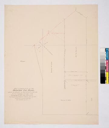
Map of that part of Rancho La Brea which is situate in Sec.s 3 & 10 T. 1S. R.14W.; belonging to Mrs. Ida Hancock
Manuscripts
Rancho La Brea detail: property belong to Mrs. Ida Hancock. Other property owners: Samuel M. Little, Plumer [Plummer?], Cole, Wilson. Mountain Avenue indicated
mssSolano SR_Map_0033

Sketch map of Ranchos Rodeo de las Aguas and La Brea
Manuscripts
Rancho La Brea. Featuring sections 7-9; Lot No. 11 Rancho La Brea, No. 38 Rancho San Antonio or Rodeo de las Aguas. Title supplied by cataloger.
mssSolano SR_Map_0135.02

Rancho las Ciénegas : S59 - Plat of the Rancho la Cienega finally confirmed to Anuario sic Abila et al
Manuscripts
Bordered by public lands, Ranchos La Cienega y La Tijera, Rodeo de las Aguas, La Brea. Within bound document, "Rancho La Cienega Partition... Henry H. Gird et al vs. Januario Abila et al..." copy certified by numerous officials; with color highlighting, surface details, table with boundary data, courses, distances, section numbers, markers. Title supplied by cataloger.
mssSolano SR_Box_21(04).06
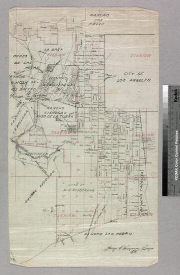
Los Angeles County public lands : T. 1S. R. 13-14W., T.2S. R. 13-14W., and T.3S. R. 13-14W. S.B.M
Manuscripts
Shows Ranchos Aguaje de Centinela, Rodeo de las Aguas, La Brea, Los Felis, Las Cienegas, Rincon de Los Bueyes, La Ballona, Cienega Paso de la Tijera, Sausal Redondo, San Pedro, Tajauta; City of Los Angeles, Land of W.S. Rosecrans. Showing structures, townships, section numbers, surface detail, parcel owners; color highlighting. Title supplied by cataloger.
mssSolano SR_Map_0769
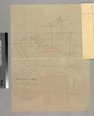
Plat of the Rancho La Brea finally confirmed to Antonio Jose Rocha
Manuscripts
Bordered by Ranchos San Antonio (or Rodeo de las Aguas), Las Cienegas, Los Felis and public land. Sixth page of document, "Rancho La Brea Patent," with color highlighting, talbe of boundary data; shows structures, courses, distances, section numbers, hachures, stations
mssSolano SR_Box_20(10).02

Map of the Rincon de los Bueyes
Manuscripts
Bordered by public lands, Ranchos Ballona, Las Cienegas, Cienega ó Paso de la Tijera, San Jose de buenos Ayres, Rodeo de las Aguas. Surveyed by order of the commissioners . . . district court . . . filed October 12th 1875 (with signatures). Structures and surface detail: dense hachures; roadways, Ballona creek, parcel owners indicated.
mssSolano SR_Map_0129.01