Rare Books
Map of the Northern, or, New England States of America
You might also be interested in
Image not available
Map of the Southern States of America, Comprehending Maryland; Virginia; Kentucky; Territory Sth. of the Ohio; North Carolina; Tennessee Governmt.; South Carolina & Georgia. by J. Russell
Rare Books
This map pasted to map 150258 by some misguided soul. MS notes: mount on 152 149 151 150257. "Russell del. et sculp Constitution R. Grays Inn Ia." Prime meridian: London. Relief: pictorial. Projection: Pseudocylindrical. Printing Process: Copper engraving. Verso Text: Map 150258.
150257
Image not available
Map of the Middle States of America
Rare Books
This map pasted on stiff paper, with map 150056 pasted to verso. MS notes: 147 on front (150) Submap: Long Island Mat sticker:862. "Comprehends New-York, New-Jersey, Pennsylvania, Delaware, and the Territory N.W. of Ohio. by J.Russell" Prime meridian: London. Relief: pictorial. Projection: Cylindrical. Printing Process: Copper engraving. Other Features: Sub-maps. Verso Text: Map 150056..
150055
Image not available
Map of northern Alabama and Georgia
Rare Books
Not a part of a larger map, this map must be from the latter part of the 19th century. Label pasted on verso: "Compiled and engraved at the U.S. Coast Survey Office ..." Prime meridian: GM. Relief: hachures. Projection: Polyconic. Printing Process: Lithography. Verso Text: MS notes: U.S. Coast 253710.
253710
Image not available
Chart of the Northern Passage between Asia & America
Visual Materials
Below neatline right: Neele, Sculp. 352 Strand. Thomson's Atlas published in Edinburgh. See map 105:016M for another copy, undated. Shows Cook's tracks 1778-1779; McKenzie's River. Minimal Compass Rose.. Prime meridian: GM. Relief: hachures. Graphic Scale: No. Projection: Cylindrical. Printing Process: Copper plate. Other Features: Explorer Tracks. Verso Text: MS note: No. 14.
093:014 M
Image not available
A New Map of the English Empire in America viz Virginia, New York [etc.]. Revised by Jon Senex, 1719
Visual Materials
Kashnor notes, "a rare and important map." This is the second & last state of the Morden map, see 105:541M, only the cartouche is changed. Cartouche surmounted by dedication. Submaps: The Harbour of Boston or Massachusetts Bay; A General map of the Coasts and Isles of Europe, Africa, and America. "I. Harris sculp: Dedication: Most humbly Inscrib'd ti Herver Edgly Herver of Clapham Esq. &c." Prime meridian: London. Relief: pictorial. Graphic Scale: Miles. Projection: Pseudocylindrical. Watermark: Fleur-di-lis. Printing Process: Copper engraving. Other Features: Sub-mapsCartouche. References: Tooley (Amer) p.63, #20. Verso Text: MS note: 542.
105:542 M
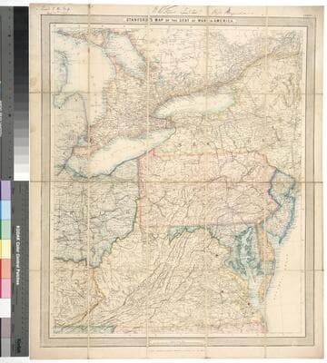
Stanford's map of the seat of the war in America
Rare Books
Kirkpatrick Catalogue entry: "2480 l Stanford, Edward, publisher. Stanford's Map of the Seat of the War in America. London, Edward Stanford, 1861. 1 sheet. [see p.]."MS notes at top of sheet give a date and identify one former owner of the map as a Lieutenant Colonel in the Rifle Brigade, though it does not say which one. Publishers' advertisement pasted to verso. MS notes: N.W. Fyns(?) Lieut. Coll. Rifle Brigade. Lent this map Aug. 31st 1862.. Prime meridian: GM. Relief: hachures. Graphic Scale: Miles. Projection: Polyconic. Printing Process: Lithography. Verso Text: MS notes: N. America Civil War 1862 RB 11489,n p maps Stanford 1861. Stamps: Kensington Public Libraries..
623654