Visual Materials
Large Draft of South Carolina from Cape Roman to Port Royal
You might also be interested in
Image not available
A Plan of Port Royal in South Carolina Survey'd by Capn. John Gascoigne
Visual Materials
Kashnor notes, "A very rare war map of South Carolina. It shows the different islands, the chief plantations, the soundings of the harbour and rivers, and indicates places of military importance." [note from 093:380] [Hilton Head Island is named Trench's Island on this map.] See 093:380 for an earlier version of this map. The RLIN record covers an earlier version printed by Jefferys & Faden. Sailing directions.. Prime meridian: London. Relief: no. Graphic Scale: Miles. Projection: Plane. Printing Process: Copper engraving. Verso Text: MS note: 348.
105:348 M

Draught of the West End of the Island of Porto Rico and the Island of Zachee. ; Draught of Sam Bay, on the South Side of Hispaniola. ; Platform Bay, on the South Side of Cape Nicholas. ; West End of the Island of Heneago.; Draught of the Island of Beata, on the South Side of Hispaniola
Visual Materials
Five maps on one sheet. Kashnor notes [Mount & Page, c.1740] Vignettes: Two views of the Island of Zachee.. Relief: no. Graphic Scale: Miles. Projection: Plane. Printing Process: Copper engraving. Other Features: Vignettes. Verso Text: MS note: 752.
105:752

Plan of Port Royal in South Carolina Survey'd by Capn. John Gascoigne
Visual Materials
Kashnor notes, "A very rare war map of South Carolina. It shows the different islands, the chief plantations, the soundings of the harbour and rivers, and indicates places of military importance." [Hilton Head Island is named Trench's Island on this map.] See 105:348 for a later version of this map. Sailing directions. Beautifully hand colored.. Prime meridian: London. Relief: no. Graphic Scale: Miles. Projection: Plane. Printing Process: Copper engraving. Verso Text: MS note: 380.
093:380 M
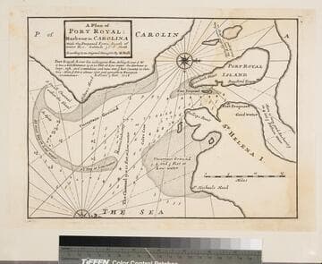
Plan of Port Royal Harbor in Carolina with the Proposed Forts, Depth of Water, &c. Latitude 32D-6 North. According to an Original Draught by H. Moll
Visual Materials
Kashnor notes, "A scarce map locating the fort at Helena Island." See 093:378 for another copy. No worn holes in this copy. Ms note: 379 (on backing). Relief: no. Graphic Scale: Miles. Projection: Plane. Printing Process: Copper engraving. Verso Text: Ms note: 379 (on backing).
093:379 S

Port Royal Dans la Caroline Méridionale Levé par le Cape Gascoigne Publié a Londres on 1776 Tradiut
Visual Materials
Kashnor notes, "An exceedingly rare chart, taken from the original English chart, which is also exceedingly rare. This was issued for the use of the commanders of French Ships-of-War and Transports during the Revolution." Relief: no. Graphic Scale: Miles. Projection: Plane. Watermark: Chained Maltese cross lettering. Printing Process: Copper engraving. Verso Text: MS notes: 82 23.
105:082 M
Image not available
A Plan of Cape Fear River from the Bar to Brunswick
Visual Materials
Kashnor notes, "A very scarce chart. It was reissued in 1800 by Laurie & Whittle." MS note: c 38. Prime meridian: London. Relief: no. Graphic Scale: Miles. Projection: Plane. Watermark: Crowned fleur-di-lis VI. Printing Process: Copper engraving. Verso Text: MS notes: 347 7.
105:347 M