Visual Materials
New and Exact Map of the Island of Barbadoes in America, According to an Actual and Accurate Survey made by William Mayo

You might also be interested in
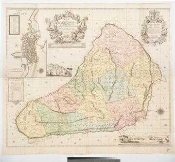
New and Exact Map of the Island of Barbadoes in America, According to an Actual and Accurate Survey made in the Years 1717 to 1721 Approved by the Royal Society & Authorized by His Majesty's Royal Licence by William Mayo
Visual Materials
Kashnor notes, "Dedicated to James Bridges, Duke of Chandos. With inset plan of Bridgetown, prospect of Codrington College, and engraving representing the making of the survey; also statistics of population." See also 105:174 for another copy. Two elaborate cartouches. Submap - A Plan of Bridgetown. A view of Codrington College. View of surveyor with plane table, and native assistants with measuring wheel, surveying pole and chain. . Prime meridian: London. Relief: pictorial. Graphic Scale: Miles. Projection: Plane. Watermark: IHS LV II --DARY. Printing Process: Copper engraving. Other Features: CartoucheSub-mapsVignettes. Verso Text: Ms notes: 745 47.
093:745 M
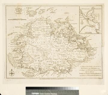
New and Exact Map of the Island of Antigua in America, according to an Actual and Accurate Survey, with the different Parishes, the Churches, Divisions, Boundaries; and a Plan of English Harbor
Visual Materials
Submap of English Harbor. Submap of English Harbor. MS note: 157 (on backing). Relief: pictorial. Graphic Scale: Miles. Projection: Plane. Watermark: Crowned seal. Printing Process: Copper engraving. Other Features: Sub-maps.
105:157 M
Image not available
Map of the Coast of New England, from Staten Island to the Island of Cape Breton as it was actually surveyed by Capt. Cyprian Southack
Visual Materials
Kashnor notes, "A very good copy of a very rare map. The map of Boston may have been taken from the Bonner Map of 1722, but it is probable that Southack made a new survey. It is the third printed plan of Boston." Kashnor dates as ca. 1740. McCorkle identifies this as a later edition of the 1735 original map. Submaps: Town of Boston in New England; Chart of the Atlantic Ocean showing the situation of Nova Scotia with respect to the British Isles.. Prime meridian: London. Relief: pictorial. Graphic Scale: Miles. Projection: Mercator. Watermark: Fleur-di-lis. Printing Process: Copper engraving. Other Features: Sub-maps. References: McCorkle 735.1. Verso Text: MS notes: 532 East end of Georges Bank from Cape St. Mary to SSW distance 115 miles..
105:532 M

Plan of the Island of Dominica Laid down by Actual Survey under the Direction of the Honorable the Commissioners for the Sale of Lands in the Ceded Island by John Byers Chief Surveyor 1776. J Bayly Sculp London
Visual Materials
Kashnor notes, "Dedicated to Thomas Shirley, Governor of Dominica, William Stuart, Lieutenant Governor, &c. An exceedingly fine map, very fully detailed, showing the lots intended for sale, with their respective numbers." Prime meridian: London. Relief: hachures. Graphic Scale: Miles. Projection: Plane. Watermark: J Whatman . Printing Process: Copper engraving. Verso Text: MS notes: 390 13 14 15.
105:390 M

The Island of Barbadoes Divided into its Parishes, with the Roads, Paths, &c.; According to an Actual and Accurate Survey / By H. Moll, Geographer
Rare Books
The Bowles' bought Moll's plates from his widow after his death in 1732, but John only went into business with his son in 1752; Thomas retired in 1763, hence the date. Removed from a copy of Moll's "Atlas minor, or, A new and curious set of sixty two maps." MS note: 75. Prime meridian: London. Relief: pictorial. Graphic Scale: Miles. Projection: Plane. Printing Process: Copper engraving.
295826

New Map of the Island of Barbadoes wherein every Parish, Plantation, Watermill, Windmill & Cattlemill is described with the name of the Present Possesor, and all things els remarkable according to a Late Exact Survey therof
Visual Materials
Kashnor notes, " very rare. An interesting minutely detailed map, in the old style with emblematic figures, full rigged ships, whales, &c." Descriptive text gives history and information on products, shipping and government. Last lines promote another Lea map of Jamaica. Kashnor dates as circa 1696. see map 105:176 for another copy, with alterations. Figures around descriptive information. Blank cartouche. Submaps of towns, not detailed. Puti on scale, whales with curly tails.. Relief: pictorial. Graphic Scale: Miles. Projection: Plane. Printing Process: Copper engraving. Other Features: CartoucheSub-mapsFigures . Verso Text: MS notes: 0 46 89 95.
105:175 M