Visual Materials
General Map of North America from the Latest Observations

You might also be interested in
Image not available
A Map of the British and French Settlements in North America
Visual Materials
Kashnor notes, "shewing the French encroachment and forts, and with an account of the English claims to the territories in dispute." Kashnor dates as ca. 1756. RLIN record suggests 1750-59. Cartouche includes Lodge's name. Detailed history of various English colonies. MS note: 622 (on backing).. Prime meridian: London. Relief: pictorial. Projection: Mercator. Printing Process: Copper engraving. Other Features: Cartouche. Verso Text: MS notes: 63 G47.
105:662 S
Image not available
North America
Visual Materials
Kashnor shows author as [N. Salmon, 1753] and notes engraved by J. Gibson. RLIN record suggests printing date as late as 1780. MS note: 342 (on backing). Prime meridian: London. Relief: pictorial. Projection: Pseudocylindrical. Watermark: VI. Printing Process: Copper engraving.
105:342 S
Image not available
A New Map of North America from the Latest Discoveries. 1763
Visual Materials
Kashnor notes, "A good map of the far west to the Lake of the Woods, and locating Fort St. Charles and Fort St. Pierre. Shows the old boundaries of Carolina, Virginia, and New England reaching beyond the Mississippi." MS note: 524 (on backing). Prime meridian: London. Relief: pictorial. Projection: Mercator. Printing Process: Copper engraving.
105:524 S
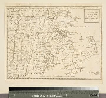
A new and accurate map of the present seat of war in North America, from a late survey
Visual Materials
Kashnor notes, "A scarce map, issued during the early part of the Revolution." Kashnor dates c.1776. RLIN record places publication in London and appearance in Universal Magazine. MS note: 107 (on backing). Prime meridian: Ferro. Relief: pictorial. Graphic Scale: Miles. Projection: Cylindrical. Watermark: Two seals. Printing Process: Copper engraving.
105:107 S
Image not available
Map of North America With the European Settlements & whatever else is remarkable in the West Indies, from the latest and best Observations
Visual Materials
Kashnor notes, "Copied from an old map, and still showing California as an island and La Hontan's River Longue. Locates Po. Sir Francis Drake, M. Nevada, and Mt. St. Martin." RLIN record gives printing location and appeared in information. Kashnor dates ca. 1740, RLIN record suggests [1745?], McLaughlin lists [1745]. Prime meridian: London. Relief: pictorial. Projection: Conic. Watermark: Fleur-di-lis. Printing Process: Copper engraving. Other Features: Cartouche. References: McLaughlin 228; Wheat 124,202; Tooley 97; Leighly 173 (Plate XXIII). Verso Text: MS notes: 105 #241.
105:241 S
Image not available
Map of that part of America which was the Principal Seat of War. in 1756
Visual Materials
Kashnor notes, "Nova Scotia to Massachusetts, and westward to Lake Ontario and the St. Lawrence." Kashnor dates as ca. 1760. RLIN record suggests printing date of 1757. MS note: 661 (on backing). Prime meridian: London. Relief: pictorial. Graphic Scale: Miles, leagues. Projection: Pseudocylindrical. Printing Process: Copper engraving.
105:661 S