Visual Materials
Plan of the General Attack upon the Island of Guadaloupe January 23rd 1759

You might also be interested in

Plan of the town & fort of Grenada / by Mr. de Caylus, Engineer General of the French Islands
Visual Materials
Kashnor dates as ca. 1760. Jolly notes publication date as December 1762. Submap of island. Submap: The Isle of Grenada. MS note: 404 (on backing). Relief: hachures. Graphic Scale: Fathoms. Projection: Plane. Printing Process: Copper engraving. References: Jolly, Brit. Periodicals LOND - 219.
105:404 S
Image not available
A Map of the Islands of Orleans with the Environs of Quebec
Visual Materials
A duplicate of map 093:329. Kashnor dates as ca. 1760. MS note: 676 (on backing). Relief: hachures. Graphic Scale: Miles. Projection: Plane. Printing Process: Copper engraving.
105:676 S
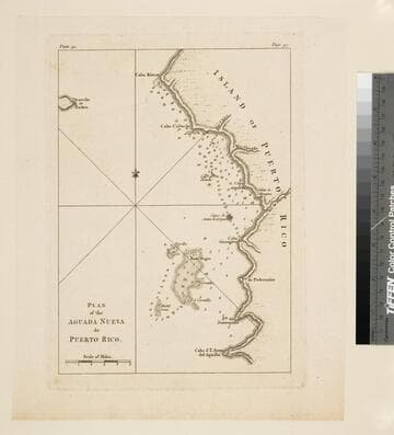
Plan of the Aguada Nueva de Puerto Rico
Visual Materials
Kashnor dates as ca. 1760. "Plate 32. (upper left) Page 97. (upper right)" Ms note: 753 (on backing). Relief: hachures. Graphic Scale: Miles. Projection: Plane. Printing Process: Copper engraving.
105:753 S
Image not available
A Map of the Country round Quebec with the Camps of the English & French at the Siege thereof. 1759
Visual Materials
Kashnor dates as [1759]. MS note: 674 (on backing). Relief: hachures. Graphic Scale: Miles. Projection: Plane. Printing Process: Copper engraving. Verso Text: MS note: S 42.
105:675 S

Plan of the Town of Basse Terre the Capital of Guadaloupe from an Authentic Survey
Visual Materials
Kashnor notes, "Issued shortly after the attack on Basse Terre during the Old French War." MS note: 778 (on backing). Relief: hachures. Graphic Scale: Yards. Projection: Plane. Watermark: P. Printing Process: Copper engraving. Verso Text: MS note: 778 (on backing).
093:778 S
Image not available
Plan of the town and fortifications of Montreal or Ville Marie in Canada
Visual Materials
See 093:299M, a larger engraving of the same material, and 093:302S for Jeffery's original versions. This copy now shows a British flag flying over the town. Kashnor dates as ca.1760. Detailed city plan. MS note: 665 (on backing). Relief: hachures. Graphic Scale: Toises, Yards. Projection: Plane. Printing Process: Copper engraving.
105:665 S