Visual Materials
Antilles oe West-India Islands

You might also be interested in
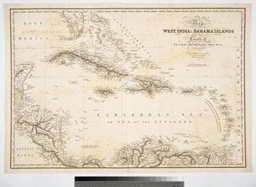
Map of the West India & Bahama Islands with the adjacent Coasts of Yucatan, Honduras, Caracas, &c
Visual Materials
Prime meridian: GM. Relief: hachures. Graphic Scale: Miles. Projection: Cylindrical. Printing Process: Copper engraving. Verso Text: MS note: 725.
093:725 M
Image not available
South America Sheet II Guayana and North Brazil
Visual Materials
MS note: 666 (on backing). Prime meridian: GM. Relief: hachures. Graphic Scale: Miles. Projection: Cylindrical. Printing Process: Engraving. Verso Text: MS note: 666 (on backing).
093:666 S

Map of the West India & Bahama Islands with the adjacent Coasts of Yucatan, Honduras, Caracas, &c
Visual Materials
See also 105:957 for a later version. Prime meridian: GM. Relief: hachures. Graphic Scale: Miles. Projection: Cylindrical. Printing Process: Copper engraving. Verso Text: MS note: 956.
105:956 M

Map of the West India & Bahama Islands with the adjacent Coasts of Yucatan, Honduras, Caracas, &c
Visual Materials
See also 105:956 for an earlier version. Prime meridian: GM. Relief: hachures. Graphic Scale: Miles. Projection: Cylindrical. Printing Process: Copper engraving. Verso Text: MS note: 957.
105:957 M
Image not available
South America Sheet IV Bolivia and Peru with a part of Brazil
Visual Materials
Kashnor dates as 1833. MS note: 643 (on backing) . Prime meridian: GM. Relief: hachures. Graphic Scale: Miles, leagues. Projection: Pseudocylindrical. Printing Process: Engraving. Verso Text: MS note: To my dear Brother E.J.R. MS note: 643 (on backing) .
093:643 S
Image not available
North America
Visual Materials
Kashnor notes, "Shows a good coast line to the North-West from California to Alaska, with the supposed course of the Missouri after Lewis. British Columbia bear the name of New Norfolk, New Cornwall, New Hanover and New Georgia." Longitude is shown as "West of Greenwich" but marked east of 180th meridian, marked as 0°. MS notes: 874 Sue at L. Danish Settlement.. Prime meridian: GM (reversed). Relief: hachures. Graphic Scale: Miles. Projection: Conic. Printing Process: Engraving, etching. Verso Text: MS note: 204.
093:204 M