Visual Materials
Chorographical Map of the Province of New York in North America, Divided into Counties, Manors, Patents and Townships; Exhibiting likewise all the private Grants of Land made and located in that Province; Compiled from Actual Surveys deposited in the Patent Office at New York

You might also be interested in
Image not available
A Map of the Located Districts in the Province of Upper Canada, Describing all the New Settlements, Townships, &c., with the adjacent Frontiers, Compiled and Corrected from the Latest Surveys in the Surveyor General's Office
Visual Materials
Kashnor notes, "A very fine large scale map,fully detailed, giving the most accurate view of Upper Canada 113 years ago. Shows all the counties west of Lake St. Clair, locating Sandwich and Amherstburg; also York, Queenston, Forts Chippewan and Erie. Buffalo is called New Amsterdam." "by William Chewitt, Senior Surveyor & Draughtsman, Under the Direction of Francis Gore Esq., Lieutenant Governor &c. &c. To whom this map is most respectfully inscribed, By William Faden, Geographer to His Majesty, and His Royal Highness the Prince Regent. Charing Cross January 1st. 1813." "Cooper Sculp." Prime meridian: GM. Relief: no. Graphic Scale: Miles. Projection: Pseudocylindrical. Printing Process: Copper engraving. Verso Text: MS notes: 684 T5 Faden Map of Upper Canada 1813.
105:684 M
![Map of the most Inhabited part of New England, containing the Provinces of Massachusets [sic] Bay and New Hampshire, with the Colonies of Conecticut [sic] and Rhode Island, Divided into Counties and Townships:](/_next/image?url=https%3A%2F%2Frail.huntington.org%2FIIIF3%2FImage%2F22APN4KVPPAA%2Ffull%2F%5E360%2C%2F0%2Fdefault.jpg&w=750&q=75)
Map of the most Inhabited part of New England, containing the Provinces of Massachusets [sic] Bay and New Hampshire, with the Colonies of Conecticut [sic] and Rhode Island, Divided into Counties and Townships:
Visual Materials
Maine is shown as the Eastern Part of Massachusets. This map derived from Thomas Jeffery's map of 1765. Prime meridian: Ferro. Relief: pictorial. Graphic Scale: Miles, leagues. Projection: Cylindrical. Watermark: Crowned fleur-di-lis JWhatman. Printing Process: Copper engraving. References: McCorkle 771.4.
105:108 M
Image not available
A New Map of the Province of Lower Canada, Describing all the Seigneuries, Townships, Grants of Land, &c
Visual Materials
Kashnor notes, "A very important map in connection with the history of Canada, giving the names of the grantees of land, and indicating the principal roads, with the dates at which they were made." Note near center of map explains the boundary agreement. The River St. Croix is formalized and agreed on October 25th 1798, signed by three commissioners and the Secretary to the Commission. "Compiled from Plans deposited in the Patent Office Quebec; by Samuel Holland, Esqr. Surveyor General. To which is added A Plan of the Rivers, Scoudiac and Magaguadavic, Surveyed in 1796,97,and 98, by Order of the Commissioners, appointed to ascertain the True River St. Croix intended by the Treaty of Peace in 1783 between His Britannic Majesty, and the United States of America." See 105:764M for another copy. Prime meridian: GM. Relief: hachures. Graphic Scale: Miles. Projection: Cylindrical. Printing Process: Copper engraving. Verso Text: MS notes: 762 S49.
105:762 M
Image not available
A New Map of the Province of Lower Canada, Describing all the Seigneuries, Townships, Grants of Land, &c
Visual Materials
Kashnor notes, "A very important map in connection with the history of Canada, giving the names of the grantees of land, and indicating the principal roads, with the dates at which they were made." Note near center of map explains the boundary agreement. The River St. Croix is formalized and agreed on October 25th 1798, signed by three commissioners and the Secretary to the Commission. " Compiled from Plans deposited in the Patent Office Quebec; by Samuel Holland, Esqr. Surveyor General. To which is added A Plan of the Rivers, Scoudiac and Magaguadavic, Surveyed in 1796,97,and 98, by Order of the Commissioners, appointed to ascertain the True River St. Croix intended by the Treaty of Peace in 1783 between His Britannic Majesty, and the United States of America." See 105:762M for another copy. Prime meridian: GM. Relief: hachures. Graphic Scale: Miles. Projection: Cylindrical. Printing Process: Copper engraving. Verso Text: MS notes: 762 S49.
105:764 M
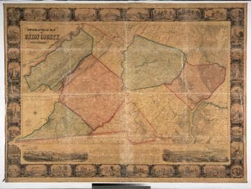
Topographical Map of Union County, New Jersey, by Ernest L. Meyer and P. Witzel, 1862
Visual Materials
Large wall map, folded, linen backed with varnished surface. Many views in the surround. Vignettes: View of Westfield from the East; View from Prospect Hill; thirty four views of estates, landmarks, manufacturing companies in the surround. Table of statistics of Union County.. "Views sketched from nature by W. T. Crane. Entered according to Act of Congress in the year 1861 by Ernest L. Meyer & P. Witzel in the Clerks Office of the District Court of the Southern District of New York. Orders for maps to be addressed to Ernest L. Meyer City Surveyor, Elisabeth, N. J. or B. Westermann & Co. 440 Broadway, N.Y." Prime meridian: GM, Washington. Relief: hachures. Graphic Scale: Miles, feet. Projection: Plane. Printing Process: Lithography. Other Features: Vignettes.
105:566 M
Image not available
Map of the most Inhabited part of New England containing the Provinces of Massachusets Bay and New Hampshire, with the Colonies of Conecticut and Rhode Island, Divided into Counties and Townships: The whole composed from Actual Surveys and its situation adjusted by Astronomical Observations
Visual Materials
Kashnor notes, "This is the old Colonial Map, originally engraved and issued by Thomas Jefferys, the plate having passed into the possession of the firm when the Jefferys and Sayer, and Sayer and Bennett firms became Laurie and Whittle." Two submaps. Patterned after Jeffreys' 1755 map, see McCorkle 755.19. Cartouche: Landing of the Mayflower at Plymouth. Submaps: Plan of the Town of Boston; Plan of Boston Harbor from an Accurate Survey.. Prime meridian: London. Relief: pictorial. Graphic Scale: Miles, leagues. Projection: Cylindrical. Printing Process: Copper engraving. Other Features: Sub-mapsCartouche. References: McCorkle 755.19.. Verso Text: MS notes: 457 England 4 Sheets (one sheet)..
093:457 M