Visual Materials
Construction of the McClure Tunnel in Santa Monica

You might also be interested in

Construction of the McClure Tunnel in Santa Monica
Visual Materials
Image of the Palisades Beach Road (part of the Roosevelt Highway and later Pacific Coast Highway) during construction of the McClure Tunnel, with the Deauville Club (with tower), the Santa Monica Athletic Club, and Wavecrest Club, at left, and Palisades Park and bluffs at right.
photCL_555_09_79

Beach Clubs along Coast Highway-Santa Monica, Calif
Visual Materials
Image of the Palisades Beach Road (part of the Roosevelt Highway and later Pacific Coast Highway), with the Deauville Club (with tower), Santa Monica Athletic Club, and Wavecrest Club, at left, and Palisades Park and bluffs at right.
photCL_555_01_1217
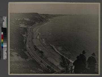
Santa Monica - Bel-Air Bay Club site
Visual Materials
Image of people overlooking the Santa Monica Bay and beach from the site of the upper clubhouse of the Bel-Air Bay Club site in 1927, with the lower clubhouse building under construction in the foreground on the beach in Pacific Palisades, California. Automobiles can be seen along the Beach Road (later the Roosevelt Highway and Pacific Coast Highway), and Santa Monica and the Santa Monica Pier are visible in the distance.
photCL_555_01_1270

Palisades Beach Road, Santa Monica
Visual Materials
Elevated view of houses along the beach in Santa Monica, California, looking south from the bluffs of Palisades Park, with railroad tracks and the Palisades Beach Road (part of the Roosevelt Highway, later Pacific Coast Highway), below, and the Santa Monica Pier and Ocean Park Pier visible in the distance. The mansion beach house of actress Marion Davies (which later became the Ocean House, or Oceanhouse hotel, and Sand and Sea Beach Club) is visible with multiple fireplaces in the foreground.
photCL_555_06_2551

Models posing as archers on the road to Palisades Park, Santa Monica
Visual Materials
Image of Ruth Hildebrandt, Margaret Webber, and Zola Page posing with bows and arrows while leaning against a rustic fence on the road to Palisades Park in Santa Monica, California. Beach houses and automobiles are seen below along the Roosevelt Highway.
photCL_555_06_579

Santa Monica, Cal
Visual Materials
Image of Sunset Trail from Linda Vista Park (present day Palisades Park) to Palisades Beach Road in Santa Monica, California. A sign hangs from a rustic wooden archway that reads "Sunset Trail to Palisades Beach Road." The 99 Steps can be seen over the Beach Road (later part of Pacific Coast Highway) at left and the Long Wharf is visible in the distance.
photCL_555_01_1321