Manuscripts
Map of Widow Botiller Tract re-subdivision
Image not available
You might also be interested in

Map of Elysian Park Tract, Being a Re-subdivision of the Solano Tract No. 2
Manuscripts
Park Row and Elysian Park to Effie St., Yuba St. to Yolo Dr.; certification notes and approval; one lot is hand colored . Verso: stamp: Olin G. McWain Blue Printing, Byrne Bldg. Los Angeles, Cal.; in pencil: "insurance". [see also Maps 743, 748]. Alt title supplied by cataloger.
mssSolano SR_Map_0749.01
Image not available
Map of the subdivision of the Clement Tract in Los Angeles
Manuscripts
This map, surveyed by John C. Goldsworthy, shows the subdivision of the Clement Tract between San Pedro Street, Pine Street, Clement Street, and Walnut Grove Street in the city of Los Angeles as of September 1887. It is measured in feet, and the scale is one hundred feet per inch.
mssHM 46692
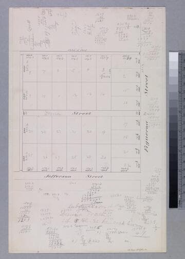
Dana Tract - subdivision map
Manuscripts
Showing Jefferson, Dana Street at Figueroa, with lot numbers, dimensions; covered in calculations; "Subdivision of the Dana Tract Lot 8 Bl. 22 Hancock Survey". Title supplied by cataloger.
mssSolano SR_Box_27(29).01
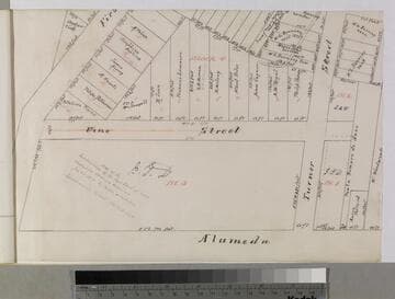
Map of the Subdivision of the Pryor Tract
Manuscripts
P. 5 of fastened document, "Vine Street Sewer," featuring Blocks 1-4 with numbered lots, owners & dimensions along Vine, between Alameda & First; also showing Turner street; red & black ink; Josephine Hopkins parcel highlighted. Alt title supplied by cataloger.
mssSolano SR_Box_32(48).01